
Terai Region in Nepal | Location, Climate, Population, Lifestyle & Districts
Nepal feels tall and wild in the mountains, but it also feels wide and alive in the Terai. At just 67-300 m in elevation, this southern belt carries 53.61% of Nepal’s population and feeds a huge part of the country through rice and wheat fields. And once you understand the Terai, Nepal’s geography suddenly becomes complete.
The Terai stretches about 885 km from west to east, from the Mahakali River to the Mechi River, with a width that changes from just 4 km to around 52 km. That’s why one district can feel like a dense jungle, and the next can feel like open farmland and border towns.
This is also one of Nepal’s three geographic regions. If you want the full national picture, read How many regions are there in Nepal?
Quick Facts About the Terai Region of Nepal
| Quick fact | Data snapshot |
| Region type | Nepal’s southern geographic region (plains) |
| East-west span | 885 km (Mahakali to Mechi) |
| Width | 4-52 km (varies by location) |
| Elevation range | 67-300 m (some places near 59-60 m) |
| Area share | 33,998.8 km² (about 23.1% of Nepal) |
| Climate | Tropical to subtropical (humid subtropical) |
| Rainfall | West 1,600-1,800 mm, East 2,500-3,000 mm (annual) |
| Monsoon share | 80%+ rainfall in June-September |
| Population (2021) | 15,634,006 people (53.61% of Nepal) |
| Density | 460 people/per square kilometer (highest in Nepal) |
| Major rivers | Koshi, Gandaki/Narayani, Karnali |
| Big highlights | Chitwan, Lumbini, Koshi Tappu, Bardiya |
What Is the Terai Region in Nepal?
The Terai (also written Tarai) is Nepal’s southern flat plain, created by soils that were brought down by rivers. In fact, fine silt, sand, and gravel were deposited in this region over millions of years.
And because the land is low and warm, the Terai became Nepal’s busiest belt for farming, trade, and settlement.
Here’s the important clarity: Terai is geographic, not administrative. That means it describes landform and elevation, not government boundaries.
Now, the confusion usually happens because of one name: Madhesh.
- Terai = the physical plain, roughly 67-300 m
- Madhesh Province = one of Nepal’s 7 provinces, with 8 districts mostly in the Terai belt
And the numbers show why the Terai matters so much. In the 2021 census, the Terai had 15.63 million people, which is 53.61% of Nepal, and the density reached 460 people/km². That is why the Terai is not “just flat land”;it is a major part of Nepal’s economy, food system, and daily life.
Where Is the Terai Region Located?
The Terai sits in southern Nepal, running like a long ribbon along the Nepal-India border. It stretches about 885 km from the Mahakali River in the west to the Mechi River in the east, and its width changes from 4 km to around 52 km depending on the district.
Geographically, the Terai lies between two big features:
- North: the Siwalik/Chure Hills, a young hill range about 15-20 km wide
- South: the Indo-Gangetic Plain, across the border in India
This location explains almost everything. Rivers flow from the Himalayas down into the Terai, carrying fertile soil. The plain stays warm for most of the year, and that supports multiple crop cycles, dense towns, and big highways.
Map of Terai Region in Nepal
A Terai map usually shows three simple ideas: east-center-west, north-south rivers, and protected areas. And once you see those patterns, the region becomes easy to read.
What a Terai map typically highlights
- Eastern Terai: higher rainfall, often 2,500-3,000 mm annually, with districts like Jhapa, Morang, Sunsari
- Central Terai: mixed settlement and wildlife zones, including Chitwan and nearby river corridors
- Western/Far-Western Terai: slightly lower rainfall, often 1,600-1,800 mm annually, with Banke, Bardiya, Kailali, Kanchanpur
Major rivers are shown on most maps
- Koshi River system (east)
- Gandaki/Narayani system (central)
- Karnali system (west)
And most tourist maps also mark two UNESCO World Heritage points in the Terai belt:
- Chitwan National Park (1984)
- Lumbini (1997)
Tip: When you travel, keep one rule: in the Terai, rivers shape land and roads, so always check bridges and monsoon conditions before long drives.
What Is the Altitude of the Terai Region in Nepal?
The Terai is Nepal’s lowest belt, and that low altitude changes everything you feel;heat, humidity, farming, and population.
- Typical elevation range: 67-300 m above sea level
- Some low points reach around 59-60 m in parts of the eastern plains
- Many key towns sit between 110-170 m, like Lumbini (110 m) and Janakpur (170 m)
- Inner Terai valleys often rise to 150-300 m
Because the land is low, the climate stays warmer, and the soil stays productive. That supports heavy farming, and it also explains why the Terai holds 53.61% of Nepal’s population and the highest density at 460 people per square kilometers.
But low altitude also brings real challenges. In May-June, heat can cross 40°C, and during June-September, flood risk increases because rivers carry monsoon water fast into flat plains.
Tip: If you’re visiting in summer, plan activities before 10:00 AM, drink extra water, and avoid long open-road travel in peak heat.
Climate of Terai Region in Nepal
The Terai has a tropical-to-subtropical feel, but it still follows Nepal’s clear seasonal rhythm. The climate is generally humid subtropical, with a strong monsoon and a cool, foggy winter.
Seasonal Climate Pattern
Pre-monsoon (March-May)
- Average highs are often around 24-28°C, but heat builds fast
- May-June can bring 40°C+ heat waves
- Rain starts slowly, with storms growing toward late May
Monsoon (June-September)
- 80%+ of annual rainfall falls in this season
- Eastern Terai can reach 2,500-3,000 mm yearly rainfall
- Western Terai often stays around 1,600-1,800 mm yearly rainfall
- Typical monsoon duration is about 112 days, but historic ranges can be 73-130 days
Post-monsoon (October-November)
- Temperatures feel calmer around 15-25°C
- Skies clear, humidity drops, and travel becomes easy
- This is why October-November is often the best season for safaris and cultural travel
Winter (December-February)
- Daytime often stays around 10-20°C
- Nights can fall to 5-10°C, sometimes below 9°C in some areas
- Dense fog can reduce visibility below 1,000 m, especially mid-December to mid-January
How Climate Shapes Life in the Terai
This climate creates a powerful cycle:
- Monsoon rain grows rice fields and tall grasslands
- Post-monsoon months improve visibility and wildlife movement
- Winter brings fog and cold waves that affect health and transport
And here’s the travel truth: the Terai is easiest when the weather is stable. That’s why October-November and January-February are often the most practical months for wildlife, heritage, and long drives.
Tip: If you’re traveling in winter, start drives after 9:00 AM to avoid peak fog hours.
Why Is the Terai Region of Nepal Famous?
The Terai is famous because it carries Nepal’s food, wildlife, heritage, and population in one long belt. And each reason has a clear data story behind it.
1. Fertile Agricultural Land
The Terai is often called Nepal’s “granary” because the numbers are heavy:
- Over 70% of Nepal’s rice production is linked to the Terai belt
- Rice farming is common in 84%+ of farming households in key Terai systems
- Wheat production is also concentrated strongly in the plains
- Agriculture contributes around 21.87% to Nepal’s GDP and supports a large share of livelihoods
Because the land is flat and warm, farming cycles can run almost year-round;rice in the monsoon, wheat and pulses in winter, and vegetables in between.
Tip: If you visit in harvest months, respect fields and irrigation channels;small damage can affect a whole season.
2. Wildlife & National Parks
The Terai holds Nepal’s most famous wildlife habitats because the grasslands, wetlands, and sal forests thrive between 67-300 m.
Key protected areas include:
- Chitwan National Park (about 932 km², UNESCO listed in 1984)
- Bardiya National Park (about 968 km², established in 1988)
- Koshi Tappu Wildlife Reserve (about 176 km², known for wetlands and wild water buffalo)
Chitwan alone is known for massive biodiversity, including 544 bird species and flagship wildlife like rhinos and tigers. And that’s why the Terai is Nepal’s top zone for safaris.
If wildlife is your main reason to visit, explore the heart of the plains with Chitwan National Park Tour Packages.
Tip: For safaris, the calm months Oct-Nov and Jan-Feb give better visibility and cooler temperatures.
3. Birthplace of Lord Buddha
The Terai is also world-famous because Lumbini sits here;Buddha’s birthplace and a UNESCO World Heritage site listed in 1997.
Lumbini’s visitor numbers show its scale:
- Around 999,000 visitors in 2023
- Including 76,210 international visitors and 266,510 Indian visitors
This isn’t just a sightseeing place. It’s a pilgrimage zone with monasteries, heritage gardens, and the Ashoka pillar history connected to 249 BCE.
To experience this heritage with a guided plan, visit Lumbini Tour Packages.
Tip: If you go to Lumbini, plan at least 4-5 hours inside the main sacred area so it doesn’t feel rushed.
4. Cultural & Ethnic Diversity
The Terai carries Nepal’s strongest blend of plains cultures, languages, and festivals. Big language communities include:
- Maithili (about 11.05% of Nepal)
- Bhojpuri (about 6.24%)
- Tharu (about 5.88%)
- Awadhi (about 2.96%)
This diversity becomes visible in food, clothing, markets, and festival calendars; especially in places like Janakpur, Birgunj, and border towns.
Tip: Cultural respect matters here; ask before photographing rituals, especially during Chhath and temple events.
What Is the Population of the Terai Region of Nepal?
The Terai is Nepal’s most populated geographic region, and the census numbers make that clear.
- Terai population (2021): 15,634,006 people
- Share of Nepal (2021): 53.61% out of 29,164,578 total population
- Terai density: 460 people/km² (highest in Nepal)
- Growth since 2011: +2,315,301 people (about 17.4% increase)
The reason is practical, not mysterious: flat land is easier for housing, farming, roads, and trade. The Terai also has major border markets, industries, and highways, which pull migration from hills and mountains over time.
Tip: In crowded Terai cities, plan travel time with buffer; short distances can take 30-60 minutes during peak traffic.
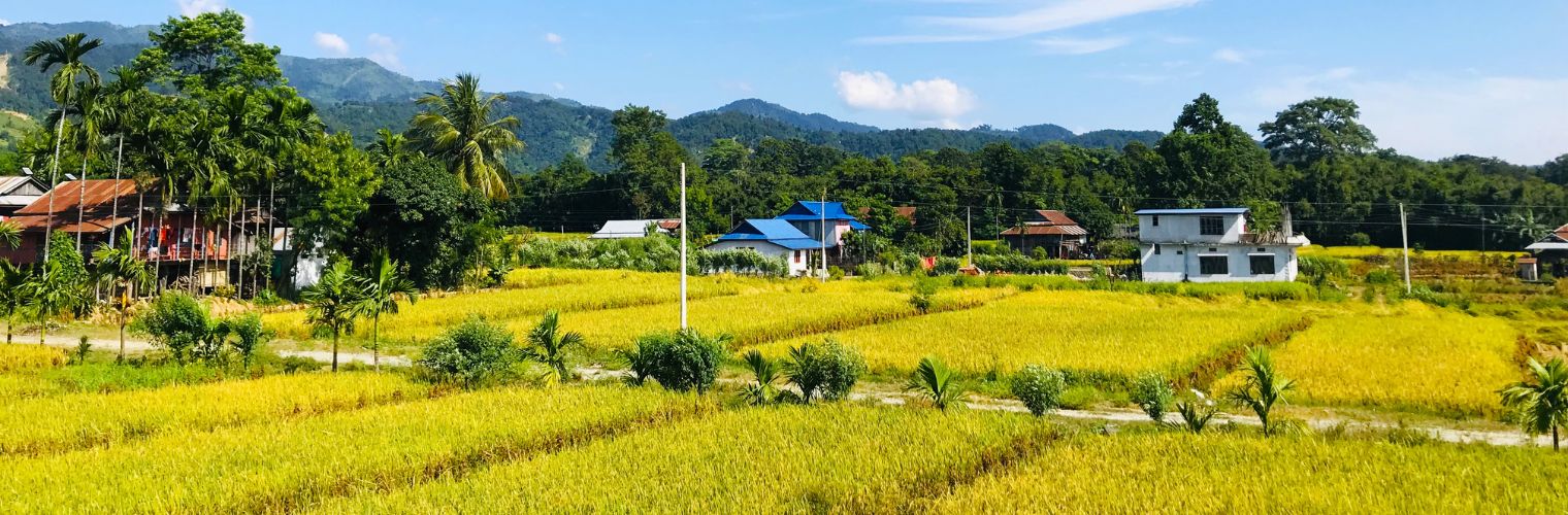
Lifestyle of the Terai Region of Nepal
Life in the Terai feels warm, busy, and seasonal. It runs on agriculture calendars, market days, festivals, and the rhythm of monsoon rain.
Rural Lifestyle
In many Terai villages, daily life follows farming cycles:
- Monsoon rice season often runs from May to September
- Winter crops like wheat and pulses often run from October to March
- Irrigated land in Nepal is heavily concentrated in the plains, supporting intense farming
Homes can still be traditional in rural areas, while towns have fast-growing concrete neighborhoods. And household structures often remain larger; Terai average household size is around 4.73 persons, with some districts like Rautahat reaching 5.94.
Tip: If you visit rural Terai, wear light clothing for 30°C+ days, but carry a thin layer for 7-10°C winter mornings.
Urban & Semi-Urban Lifestyle
Cities like Biratnagar, Birgunj, Janakpur, Nepalgunj, and Bhairahawa/Siddharthanagar are growth centers. Many are trade-linked to India, and that creates a strong transport and market culture.
Some practical lifestyle numbers also show development patterns:
- Electricity access is high across many Terai districts
- Mobile phone access is widespread (ordinary and smartphones)
- Internet access exists but still grows unevenly (many households remain offline)
Tip: In winter fog months, avoid early flights and early highway drives; visibility can drop below 1,000 m.
Food, Clothing & Daily Life
The Terai food base is simple and strong: rice, dal, seasonal vegetables, and local spices. Eastern Terai often has stronger fish and mustard-oil patterns near rivers, while western Terai has deep Tharu cultural traditions and forest-edge farming.
Festival life is also powerful here; Chhath (often Oct-Nov), Holi (March), Diwali (Oct-Nov), and major Janakpur events in late autumn.
Tip: If you’re visiting during festivals, book rooms early;popular cities can fill up 7-14 days ahead.
Districts in the Terai Region of Nepal
The Terai belt is commonly described through a clean district list, stretching from east to west along the plains. Across Nepal, the Terai is often counted as about 20 main Terai districts, plus Inner Terai valleys that blend plains and foothills.
Eastern Terai Districts
- Jhapa, Morang, Sunsari, Saptari, Siraha
Central Terai Districts
- Dhanusha, Mahottari, Sarlahi, Rautahat, Bara, Parsa, Chitwan, Nawalparasi (partial/Inner Terai)
Western Terai Districts
- Rupandehi, Kapilvastu, Dang, Banke, Bardiya, Kailali, Kanchanpur
The Inner Terai valleys, like Dang, Deukhuri, and Chitwan Valley, often sit around 150-300 m, and they feel slightly different from the outer plains because they lie between hill ridges.
Tip: When planning routes, remember that “Terai districts” can include Inner Terai valleys, so always check road elevation and weather risk in monsoon months.
Terai Region vs Hill and Mountain Regions of Nepal
Nepal becomes much easier when you compare the three geographic regions in one glance.
| Feature | Terai | Hill | Mountain |
| Altitude | 67-300 m | 600-3,500 m | 3,500-8,848 m |
| Climate | Tropical-subtropical | Temperate | Alpine-tundra |
| Population (2021) | 53.61% | 40.31% | 6.08% |
| Density | 460/km² | 140/km² | 34/km² |
| Main identity | Farming + trade + heritage | Cities + culture + trekking | High trekking + mountaineering |
If you want the full national explanation behind these systems, read How many regions are there in Nepal?
Tip: Travelers often mix “Everest region” with “Mountain region.” One is a trekking area; the other is a geographic belt by altitude.
Best Places to Visit in the Terai Region
The Terai is perfect when you want Nepal’s nature and heritage without high-altitude pressure. The best experiences here usually sit between 67-300 m, with easy roads and warm weather.
Top places people actually love
- Chitwan National Park: jungle safaris, birding, rhino habitats, often best in Oct-Nov and Jan-Feb
- Lumbini: sacred birthplace zone, best in Oct-Nov and Feb-Mar
- Janakpur: temples, Mithila culture, huge festivals in Nov-Dec
- Koshi Tappu: wetlands and birdwatching, especially around migration seasons
- Bardiya: quieter wilderness feel than Chitwan, often best visibility in cooler months
Tip: If you have only 3-5 days, choose either a wildlife focus (Chitwan/Bardiya) or a heritage focus (Lumbini/Janakpur) so travel time stays comfortable.
Is the Terai Region Safe and Suitable for Travel?
Most travelers find the Terai safe and welcoming, but the safety needs change by season. This region is low and warm, so your main concerns are heat, fog, and monsoon flooding, not altitude sickness.
Practical safety reality (by season)
- Oct-Nov: stable weather, best visibility, great for wildlife and driving
- Dec-Jan: fog can reduce visibility under 1,000 m, and cold waves can affect comfort
- May-Jun: extreme heat can cross 40°C, so dehydration risk rises
- Jun-Sep: monsoon brings 80%+ of annual rain, and some roads face floods or delays
Health-wise, carry water, use sun protection in hot months, and plan winter transport later in the morning. And if you’re going into parks, follow ranger rules; wildlife zones are not places for shortcuts.
Tip: In monsoon season, always check local road updates before long drives, especially near river crossings.
Why the Terai Region Is Essential to Understanding Nepal
Nepal can feel like a country of peaks, but the Terai proves Nepal is also a country of plains. At just 23.1% of Nepal’s land area, it carries 53.61% of the population and supports the food systems that keep the nation moving. And when you connect wildlife in Chitwan, spiritual heritage in Lumbini, and daily life across 20+ Terai districts, Nepal starts to look complete.
In the end, Nepal is not only about height. It is balance. And the Terai is one of the strongest pieces of that balance.
Frequently Asked Questions About the Terai Region of Nepal
Is Terai a province or a geographic region?
Terai is a geographic region, not a province. It is Nepal’s low plains at 67-300 m, while provinces are administrative units.
How hot does Terai get in summer?
In May-June, temperatures can rise above 40°C, especially during heat waves in the plains.
Which national parks lie in the Terai?
Major protected areas include Chitwan National Park (932 km²), Bardiya National Park (968 km²), and Koshi Tappu Wildlife Reserve (176 km²).
Why do most people live in the Terai?
Because the land is flat and productive, in 2021, the Terai had 15.63 million people, which is 53.61% of Nepal, with 460 people/km².