Ama Dablam Expedition
TripAdvisor Reviews Recommended by 99.99% travelers
USD 7500
Nepal
30 Days
Challenging
6,812 meters at AmaDablam Summit
Hotel/Teahouses/Lodge/Tent
Private Vehicle/Local Bus/Flight
2-15
Autumn Season
- Summit elevation 6,812 m (22,349 ft) in the heart of the Khumbu Region Nepal.
- Climbs the classic Southwest Ridge, a highly technical alpine route.
- close views of Mount Everest, Lhotse, and surrounding peaks from the summit.
- Scenic approach via Lukla Airport and Namche Bazaar.
- 28-30 days expedition including acclimatization rotations.
- Requires prior 6,000m climbing experience.
- Features mixed rock, ice, and exposed fixed rope sections.
- Steep technical climbing above Camp 1 and Camp 2
- Fully supported Base Camp with a professional and strong climbing Sherpa team.
- Climbs the classic Southwest Ridge, a highly technical alpine route.
Ama Dablam Expedition Overview
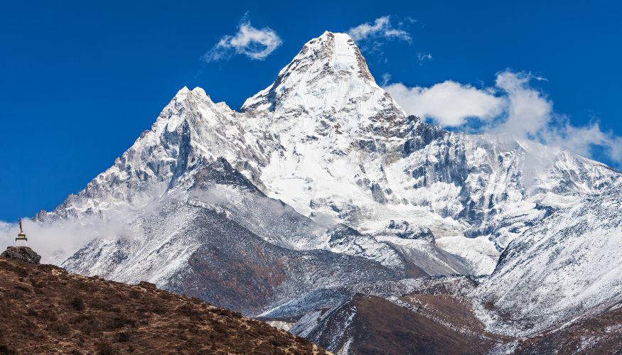
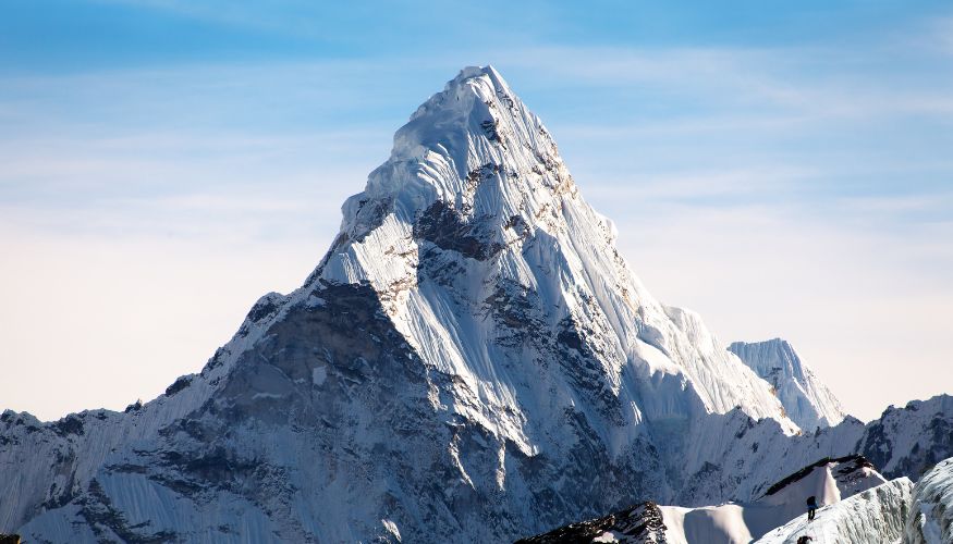
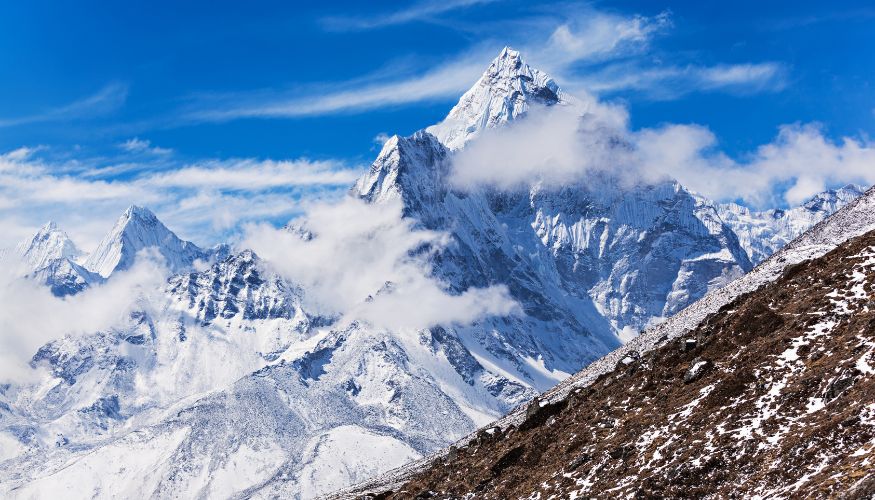
Ama Dablam is considered one of the most beautiful mountains in the world, and it has captured the attention of climbers with its pyramid-shaped peak and the technical challenges it poses to climbers of all experience levels.
Ama Dablam is a 6,812-meter (22,349 feet) peak that towers above the Khumbu region of Nepal. The peak is visible from Everest Base Camp and is known to the Sherpas as the “Mother’s Necklace” because of the glacier that hangs from its summit like a necklace.
Ama Dablam is part of Sagarmatha National Park and is a beautiful sight for trekkers traversing the Everest region.
The first ascent of the peak was made on March 13, 1961, by a joint expedition led by Sir Edmund Hillary via the Southwest Ridge, which is the standard route to the summit today.
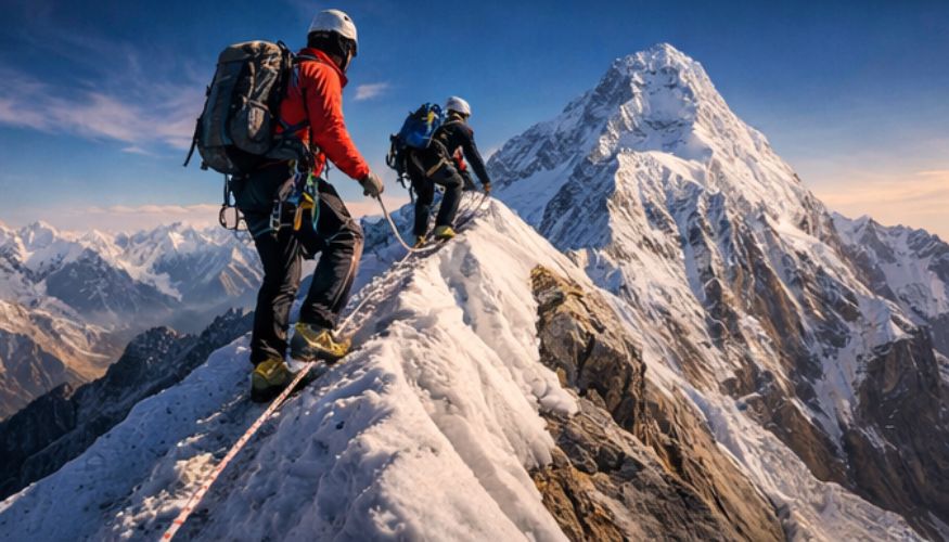
Ama Dablam is a technical mountain that requires the skills of an alpine climber to navigate its rock, ice, and fixed-rope sections. The expedition to Ama Dablam requires experience with crampons, ice axes, jumars, and steep-ridge climbing. The mountain is not a trekking peak and requires previous climbing experience to tackle its technical challenges.
The expedition duration ranges from 28 to 30 days, which includes trekking to base camp, acclimatization, setting up high camps, and the summit push.
The best time to climb the peak is in the autumn season, when conditions are clear, skies are clear, precipitation is low, and temperatures are pleasant. The second-best time is spring, but the weather may be less consistent, with afternoon clouds and a chance of snowfall.
Why Climb Ama Dablam?
Ama Dablam Climbing is not just about the summit, 6,812 meters. It is about placing your feet on one of the most technically revered and aesthetically pleasing mountains in the Himalayas, located in Nepal’s Khumbu Region.
Technical Challenge
Ama Dablam presents a high-standard technical challenge, with steep rock, ice, and ridge traverses. The Southwest Ridge Route demands experience with crampons, ice axes, ropes, and rock climbing up to 5.7, well beyond what is required for any of the popular trekking peaks.
Popular Himalayan Peak
Ama Dablam is known as the “Matterhorn of the Himalayas” for its striking pyramidal shape, making it one of the world’s most photographed mountains. It towers over the Everest Base Camp trekking route, inspiring all climbers with its beautiful mountain views.
Preparation for 8,000m Expedition
Ama Dablam Climbing is a perfect training ground for aspiring 8,000m Expedition climbers. The climb will be an essential experience for aspiring Everest or Manaslu climbers, as it will help acclimatize and gain valuable experience necessary for any of the world’s highest mountains.
Stunning Exposure & Mountain Views
There is fantastic exposure on narrow ridges with drops of a thousand meters or so. The views from the summit include Everest, Lhotse, Nuptse, Makalu, and the entire Khumbu Region, with beautiful Himalayan views in all directions.
Prestige Climb
Climbing and summiting Ama Dablam will give you prestige as a climber, as it is a technical climb beyond what most people achieve, even if they have experience with high-altitude treks.
Is Ama Dablam Expedition Safe?
Ama Dablam is a climb that, with proper preparation and professional support, tends to be safer for experienced mountaineers. The popular route via the Southwest Ridge has fixed ropes in place, the services of experienced Sherpas, a medical setup at Base Camp, emergency oxygen, weather updates, and helicopter rescue services until about 6,500 m in decent conditions. Being lower in altitude than the 8,000 m peaks also reduces the risks associated with extreme altitude.
However, it is still a serious climb in the Himalayas, which entails risks like rockfall, icefall, ridges that drop over 1,000 meters, bad weather, and altitude sickness if you ascend higher than 6,000 m. It is safer than climbing any of the 8,000 m peaks but tougher than a trekking peak like Island Peak.
Ama Dablam Expedition Route
The Ama Dablam expedition takes the Southwest Ridge, which is the standard and most popular route established during the first ascent in 1961. This classic route provides sustained technical climbing with spectacular exposure. Here is a route breakdown.
| Day | Route | Elevation (m / ft) |
| Day 1 | Arrival in Kathmandu | (1,350 m/4,429 ft) |
| Day 2 | Rest in Kathmandu, expedition briefing, Permit management, Valley Sightseeing, and Preparation | (1,350 m/4,429 ft) |
| Day 3 | Fly from Kathmandu to Lukla, then trek to Phakding | (2,651 m/8,698 ft) |
| Day 4 | Trek from Phakding to Namche | (3,440 m/11,286 ft) |
| Day 5 | Acclimatization Day in Namche | (3,440 m/11,286 ft) |
| Day 6 | Trek from Namche to Pangboche | 3,985 meters (13,074 ft) |
| Day 7 | Trek from Pangboche to Ama Dablam Basecamp | 4,600 meters (15,092 ft) |
| Day 8 | Base Camp Preparation & Acclimatization Day at Base Camp | 4,600 meters (15,092 ft) |
| Day 9-20 | Training at Base Camp and Rotation: Base Camp – Rotation (Camp 1 and Camp 2) – Base camp 4,600m | |
| Day 21-25 | Summit Push Days: Basecamp – Camp 2 – Summit (6,812m) and back to Camp 2 or Base Camp | 6,812 meters (22,349 ft) |
| Day 26 | Trek from Base Camp to Namche Bazaar | (3,440 m/11,286 ft) |
| Day 27 | Trek from Namche Bazar to Lukla | (2,850 m/9,350 ft) |
| Day 28 | Fly from Lukla to Kathmandu and transfer to the Hotel | (1,350 m/4,429 ft) |
| Day 29 | Farewell and Certificate Destruction | (1,350 m/4,429 ft) |
| Day 30 | Final Departure | (1,350 m/4,429 ft) |
Note: if you are an experienced climber with limited time but want to climb shortly, we can customize the itinerary.
Cost of the Ama Dablam Expedition
The Ama Dablam expedition cost will range from USD $7,500 to $12,000, depending on the level of service. Group Budget expeditions begin at $7,500 with basic services, while fully supported expeditions with experienced Sherpa guides and deluxe facilities cost $12,000+ or more.
Detailed Cost Breakdown Table
| Category | Cost (USD) | Details |
| Permit Fees | $400-$600 per person (depend on season) | Nepal government climbing permit, obtained through a registered expedition company |
| Government Liaison Officer Fee | $2,500-$3,000 per expedition (shared) | Government-mandated fee per expedition covers salary, equipment, insurance, and logistics. |
| Base Camp Service | $2,000-$3,500 per person | Base camp setup, dining tent, kitchen staff, cook, meals, communications per person |
| Climbing Sherpa Guide | $3,000-$5,000 | Experienced climbing Sherpa for route fixing, high-altitude support, safety backup, and summit assistance |
| Oxygen (Optional) | $400-$600 | Emergency backup oxygen |
| Equipment | $1,500-$3,000 | Personal climbing gear, high-altitude clothing, boots, harnesses, and technical equipment |
| Travel Insurance | $200-$500 | Travel and evacuation insurance covering up to 7,000m is mandatory for helicopter rescue |
| Total Cost | $7,500-$12,000 | Complete expedition cost depending on service level, companies, and support |
If you want to know more about the full package cost details, let’s talk with our expert.
Short Itinerary
- Day 1: Arrival in Kathmandu
- Day 2: Rest in Kathmandu, expedition briefing, Permit management, Valley Sightseeing, and Preparation
- Day 3: Fly from Kathmandu to Lukla, then trek to Phakding
- Day 4: Trek from Phakding to Namche
- Day 5: Acclimatization Day in Namche
- Day 6: Trek from Namche to Pangboche
- Day 7: Trek from Pangboche to Ama Dablam Basecamp
- Day 8: Base Camp Preparation & Acclimatization Day at Base Camp
- Day 9-20: Training at Base Camp and Rotation: Base Camp - Rotation (Camp 1 and Camp 2) - Base Camp 4,600m
- Day 21-25: Summit Push Days: Basecamp - Camp 2 - Summit (6,812m) and back to Camp 2 or Base Camp
- Day 26: Trek from Base Camp to Namche Bazaar
- Day 27: Descent from Namche Bazaar (3,440 m / 11,286 ft) to Lukla
- Day 28: Fly from Lukla to Kathmandu and transfer to the Hotel
- Day 30: Final Departure
Detailed Itinerary
Day 1: Arrival in Kathmandu
Trek Distance
N/A
Highest Altitude
1,350 m / 4,430 ft at Kathmandu
Trek Duration
N/A
Meals
Breakfast
Upon arrival at Tribhuvan International Airport, you will be welcomed by our team representative holding a khata scarf, then driven to your hotel in Thamel. The drive would take about 20-30 minutes, depending on road conditions and traffic jams. Kathmandu is a valley surrounded by green hills, where you can see Nepal’s urban landscape: busy streets, colorful houses, and temple roofs rising above the horizon.
After checking into your hotel and freshening up, you can relax after a long flight or explore Thamel, a vibrant area with numerous trekking shops, restaurants, and other cultural attractions. In the evening, you can enjoy a welcome dinner with authentic Nepali cuisine and culture. This is a good time to mingle with other members of the expedition team.
Note: Make sure you have all travel documents and insurance ready for tomorrow.
Day 2: Rest in Kathmandu, expedition briefing, Permit management, Valley Sightseeing, and Preparation
Trek Distance
N/A
Highest Altitude
1,350 m / 4,430 ft at Kathmandu
Trek Duration
N/A
Meals
Breakfast
Day two is for expedition readiness and logistics. In the morning, our expedition leader conducts a briefing on the climbing strategy, acclimatization, the climb’s structure, safety arrangements, and emergency response. All necessary permits for the climbing will be arranged, including the Ama Dablam climbing permit and other documents. A technical gear inspection is conducted to ensure that all necessary expedition equipment is in good condition, including boots, crampons, harnesses, and high-altitude gear.
Depending on the schedule, a short cultural excursion is made to Swayambhunath or Boudhanath Stupa for a beautiful view of the surrounding area before venturing into the Himalayas to explore the cultures of Hindus and Buddhists.
Day 3: Fly from Kathmandu to Lukla, then trek to Phakding
Trek Distance
7 to 8 km
Highest Altitude
2,850 m at Lukla
Trek Duration
3 to 4 hours trekking, plus flight time 40 Minutes
Meals
Breakfast/Lunch/Dinner
The trek commences with an early morning scenic flight to Lukla, considered one of the world’s most spectacular mountain airstrips. The short flight offers a breathtaking bird’s-eye view of the Himalayan landscape and, on clear days, even a glimpse of some of the highest mountains on Earth, such as Mount Everest, Lhotse, and Ama Dablam.
Once landed, preparations are made to begin the first trek through the valley, along forested routes, Sherpa villages, prayer flags, mani walls, and suspension bridges. The trek is relatively easy and mostly downhill, making it an excellent introduction to trekking.
Phakding is a serene village located along the valley, with excellent teahouses and a pleasant mountain environment. It is an ideal place to begin the trek to the Khumbu region.
Trekking Note: For trekkers planning to trek during peak seasons (autumn and spring), it is important to note that Lukla flights operate from Ramechhap Airport instead of Kathmandu due to air traffic regulations. It is essential to make an early start on the road to Ramechhap from Kathmandu.
Day 4: Trek from Phakding to Namche
Trek Distance
10 to 11 km
Highest Altitude
3,440 m / 11,286 ft at Namche Bazar
Trek Duration
6 to 7 hours
Meals
Breakfast / Lunch / Dinner
The trek starts slowly through the Dudh Koshi River valley, through blue pine forests, with suspension bridges to cross, including the famous Hillary Suspension Bridge at Monjo. The entrance to Sagarmatha National Park is at the Monjo checkpoint. The dense forest provides habitat for Himalayan tahr, musk deer, and even the elusive red pandas. The Dudh Koshi River joins Bthe hote Koshi River at their confluence (2,835m).
The last stretch of the day involves a grueling 2-3-hour ascent, gaining 600 meters in altitude over zigzagging switchbacks. At the halfway point, there’s a viewpoint with the first spectacular views of the day for the expedition. The views of Everest (8,848m), Lhotse (8,516m), and Ama Dablam (6,812m) towers rise majestically above the valley.
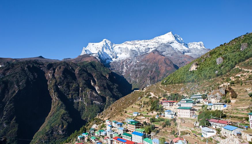
The Sherpa capital of Namche Bazaar (3,440m) comes as a surprise. It’s an amphitheater-shaped town carved into the mountainside. The prosperous trading center offers bakeries, equipment shops, internet cafes, restaurants, the Saturday market, and the Sagarmatha National Park Museum. The sun sets over Kongde Ri (6,187m) and Thamserku (6,623m), with Ama Dablam in golden light.
Day 5: Acclimatization Day in Namche
Trek Distance
3 to 4 km
Highest Altitude
3,880 m / 12,730 ft at Khumjung
Trek Duration
3 to 4 hours
Meals
Breakfast / Lunch /Dinner
Today is acclimatization day in Namche it means accordance with the “climb high, sleep low” approach. Hiking is a form of physical activity that promotes acclimatization and the production of red blood cells.
After Breakfast, we will hike to Everest View Hotel (3,880m), the highest hotel in the world, 2 hours from Namche. The hike goes through the Syangboche village (3,720m), which features a helicopter landing site. The hike passes through forests of rhododendron and juniper. The hotel’s viewpoint offers a 180-degree view of Everest, Lhotse, Ama Dablam, Thamserku, Kongde, and Khumbila. It is the best viewpoint in the Khumbu area.
Alternative options: Khumjung village (3,780m), which features the Edmund Hillary School and the monastery housing the Yeti’s scalp, or the village of Kunde (3,840m), which houses the Hillary Hospital.
In the evening, visit the Tibetan market on Saturdays (if the schedule permits), the Sherpa Museum, which displays the history of mountain climbing, or the Sagarmatha National Park Museum for information on the environment. Overnight in Namche Bazar.
Day 6: Trek from Namche to Pangboche
Trek Distance
10 to 13.5 km
Highest Altitude
3,985 meters (13,074 feet) at Pangboche
Trek Duration
6 to 7 hours
Meals
Breakfast / Lunch /Dinner
The trail continues gradually along the valley’s eastern slope, offering views of Everest, Nuptse, and Lhotse. Cross Kyangjuma (3,550m) and Sanasa (3,600m) through alpine meadows with yak herds.
At 3,700m, take the higher route through rhododendron, birch, and juniper woods.
Tengboche Monastery (3,860m) – Khumbu’s most important Buddhist monastery, situated dramatically with Ama Dablam as a backdrop. It houses 60 monks, colorful murals, and Buddha statues. It is possible to attend an afternoon prayer ceremony (3 PM).
Descend steeply through the rhododendron forest, then cross the Imja Khola bridge (3,710m), climb through Deboche (3,820m) and Milingo (3,870m).
Pangboche (3,985m) – the highest permanent settlement with 300+ year-old Pangboche Gompa (the oldest monastery in Khumbu, once home to the Yeti’s hand).
Evening close-up views of Ama Dablam’s south face with stunning sunset alpenglow on the hanging glacier.
Day 7: Trek from Pangboche to Ama Dablam Basecamp
Trek Distance
5-6 Km
Highest Altitude
4600m at Ama Dablam Base Camp
Trek Duration
5–6 hours
Meals
Breakfast / Lunch /Dinner
After breakfast, we will begin our journey to the Ama Dablam Base Camp. trail, which branches off from the main route to Everest. Climb through alpine terrain with limited vegetation, such as juniper scrubland and rocky moraine fields with glacial rivers, prayer flags, and memorial chortens. The view opens to Kantega (6,782m), Thamserku (6,623m), and the Lhotse-Nuptse wall. Possible sighting of Himalayan Griffon vultures.
Cross the lateral moraine ridges and reach Base Camp (4,600m) next to the Mingbo La Glacier, directly beneath the 2,200m south-west face of Ama Dablam. The camp consists of the dining tent, kitchen tent, communication tent, toilets, and sleeping tents with solar lighting. Afternoon: camp orientation, meeting the climbing Sherpas, acclimatization plan briefing, and an explanation of the route to Camp I (5,700m). Nighttime temperatures range from -10°C to -15°C
Day 8: Base Camp Preparation & Acclimatization Day at Base Camp
Trek Distance
N/A
Highest Altitude
4600m at Base Camp
Trek Duration
N/A
Meals
Breakfast / Lunch /Dinner
Today is a rest and preparation day for altitude adaptation. in Morning, gear organization and safety equipment check (carabiners, harnesses, helmets, crampons, headlamps, ascenders). Technical training: jumar ascending on fixed ropes, rope changes at anchor points, clipping techniques, rappelling with a safety line, cand ommunication techniques.
Short acclimatization hike to 100-200m above the campsite on the initial slopes of the climb. Scenic views of steep rock buttresses, hanging glaciers, and the ridge line. Afternoon: detailed brief on climbing strategies, including rotations, load carrying, timing, and summit plans, weather conditions, and emergency evacuations.
Traditional Buddhist pooja to bless the climb with a lama chanting Buddhist prayers, burning juniper incense, offering rice or tsampa to mountain deities, and tying prayer flags. All members will participate and be given rice and silk scarves to take along on the climb. Evening: organizing summit bags with down suit, insulated boots, gloves, goggles, face protection, energy snacks, insulated water bottles, and emergency items.
Day 9-20: Training at Base Camp and Rotation: Base Camp - Rotation (Camp 1 and Camp 2) - Base Camp 4,600m
Trek Distance
Every Day 3-4 Km
Highest Altitude
6000m at Ama Dablam Cap 2
Trek Duration
Every day 6-7 Hrs
Meals
Breakfast / Lunch /Dinner
Cross boulder fields and moraine to fixed ropes at 4,900m. Steep rock slabs and mixed ground with jumar ascenders. Rope sections are 50-60 meters long. Steep sections are at 45-55 degrees. Safe transition to the next section. Hanging glacier at 5,400 meters. Crevasses, severe exposure. Camp I is on a narrow ridge with 360° views of Everest, Lhotse, and Khumbu. Camp I. Descend to base camp the same day or spend the night at Camp I.
Rest Days: 1-2 days at base camp. Physiological rest. The body replenishes red blood cells, adjusts breathing rate, and repairs tissues. Walks, equipment checks, hydration with 4-5 liters of water, carbohydrate-rich meals.
Days 13-15: Second Rotation – Camp II (6,000m)
Base camp to Camp I (possibly overnight), then onward the next day. “Mushroom ridge” with ice sculptures formed by the wind. Mixed rock and ice (50-65°). Rock sections requiring climbing ability (5.5-5.7 grade). “Rock band” at 5,900m: steep and technical rock with crampons – Ama Dablam’s crux pitch. Camp II is very exposed, on a thin ridge with thousand-meter drops on either side, and strong winds. Sleep one night, then descend back to base camp.
Days 16-18: Rest, weather forecasting, equipment preparation, and rest.
Days 19-20: Final preparation, packing of summit gear, safety considerations, Sherpa support, weather forecasts, and waiting for the weather window.
Day 21-25: Summit Push Days: Basecamp - Camp 2 - Summit (6,812m) and back to Camp 2 or Base Camp
Trek Distance
Every Day 2-3km
Highest Altitude
6,812m at Ama Dablam Summit
Trek Duration
6-8 Hrs
Meals
Breakfast / Lunch /Dinner
Day 21: Base Camp to Camp I (5,700m) Climb: 6-8 hours | Elevation Gain: 1,100m
Wake up early, around 6-7 AM, and follow the familiar route. Arrive at the campsite by early afternoon, rest, hydrate, and prepare for the next day. Wake up during the night and organize the gear needed to reach the summit, check the headlamps, and fill the water bottles with hot tea and soup. Sleeping is difficult because of the high altitude and the wind.
Day 22: Camp I to Camp II (6,000m) Climb: 5-6 hours | Elevation Gain: 300m
Wake up around 7-8 AM and begin the climb to the next camp.
This part includes technical ridges and rock bands, and the climb is exposed.
Wake up during the night, lay out the clothes to wear to the summit, prepare the food to pack in the pockets, and fill the water bottles. Sleeping around 6-7 PM is almost impossible due to adrenaline and altitude.
Day 23: SUMMIT DAY – Camp II to Summit (6,812m) Duration: 10-14 hours round trip | Elevation Gain: 812m
11 PM-12 AM: Wake up with hot tea and a light breakfast. Wear all gear for the summit.
12-1 AM: Leave the camp. Steep mixed climb on fixed ropes, crampons front-pointing, and jumar ascending. Visibility is poor because of the darkness.
2-4 AM: Cross over rock outcrops. Cross over the Yellow Tower and Grey Tower, near-vertical rock buttresses. Methodical transitions between anchors are critical. Temperatures are -20°C+.
4-6 AM: Pre-dawn light reveals the Himalayas. The summit ridge has a knife-edge arête with thousand-meter drops on either side. Absolute concentration of the mind is required.
6-8 AM: The steepness of the final pyramid is 60-65 degrees. Every step takes several breaths, half the oxygen of sea level.
8-9 AM: We finally reach the summit (6,812m/22,349ft)! 360° view: Everest (8,848m), Lhotse (8,516m), Nuptse (7,861m), Makalu (8,463m), Cho Oyu (8,188m), numerous 6,000-7,000m peaks. 15-30 minutes maximum.
9 AM-2 PM: Descend to Camp II. Rappel carefully, though exhausted. Snow conditions make avalanches more likely, and dehydration. Arrive at Camp II midday. Rest
Days 24-25: Descent to Base Camp
Complete descent 1-2 days. Concentration required on rappels and exposed sections. Base camp arrival: celebration, relief, thicker air at 4,600m.
Day 26: Trek from Base Camp to Namche Bazaar
Trek Distance
15 to 20 Km
Highest Altitude
4600m at Ama Dablam Base Camp
Trek Duration
6 to 7 hours
Meals
Breakfast / Lunch /Dinner
Trekback from base camp to Namche Bazar, through Pangboche. over Tengboche, down the valley, up to Namche. Use trekking poles to protect knees. Hot shower, cold beer, celebration at bakeries/restaurants. Deep sleep in oxygen-rich air.
Day 27: Descent from Namche Bazaar (3,440 m / 11,286 ft) to Lukla
Trek Distance
18 to 19 km
Highest Altitude
3,440 m / 11,286 ft at Namche Bazar
Trek Duration
6 to 7 hours
Meals
Breakfast/Lunch/Dinner
Descend through dense vegetation. Cross Phakding, then continue through Dudh Koshi, passing through pine forests. Arriving at Lukla: celebration dinner with guide/Sherpa team, stories, photos, thanks. Tip Sherpa team. Check with the guide for flight time.
Day 28: Fly from Lukla to Kathmandu and transfer to the Hotel
Trek Distance
136 km (85 miles)
Highest Altitude
2850m at Lukla
Trek Duration
40 Minutes by Flight
Meals
Breakfast and Dinner
Early flight with final mountain views. Transfer to the hotel. Hot shower, real bed, oxygen abundant. Afternoon: shopping, massage, rest. Evening: farewell dinner with certificate presentation.
Buffer for flight delays from Lukla. Certificate presentation. Free time: sightseeing, shopping, dining, spa, rest. Journal experience, review photos.
Day 30: Final Departure
Trek Distance
N/A
Highest Altitude
1350M at Kathmandu
Trek Duration
N/A
Meals
Breakfast
Airport transfer 3 hours prior to flight. Khata farewell. 2-3 weeks of rest after the expedition.
Cost Includes
- Airport pick up and drop off by private car, hiace, or bus depending on group size
- All required ground transportation between Kathmandu and Ramechhap and return
- Domestic Lukla flight ticket including domestic airport taxes
- Three nights accommodation in a standard 3 star hotel in Kathmandu on twin sharing basis with breakfast
- Three meals a day during trek and at base camp (breakfast, lunch, dinner), including tea/coffee.
- Accommodation in local teahouses and lodges throughout the trek and individual tents, dining tent, kitchen tent, tables, chairs, and toilet tent at Base Camp.
- Sagarmatha National Park permit and required local trekking permits.
- Amadablam Expedition Climbing Permits.
- Licensed holder experienced trekking guide and Professional high-altitude Sherpa guide for climbing.
- Team contribution to fixed rope installation above Camp 1, 2, and 3.
- Nepal Government Mandatory liaison officer fees and garbage deposit management.
- Porter support during the trek with one porter shared between two trekkers
- All guide and porter expenses, including wages, meals, accommodation, insurance, and required gear
- Basic first aid kit carried during the trek
- Eco Nepal Trekkers duffel bag provided for use during the trek and returned after completion
- Licensed cultural guide for Kathmandu sightseeing where applicable
- Private vehicle for Kathmandu Valley sightseeing where applicable
- One farewell dinner at a traditional Nepali restaurant
- Climbing completion certificate
- Government taxes, VAT, and office service charges
Cost Excludes
- International flight tickets and international airport departure taxes
- Nepal entry visa fee
- Travel insurance including high altitude emergency evacuation coverage
- Personal trekking and climbing equipment and clothing
- Lunch and dinner while in Kathmandu
- Entrance fees for Kathmandu Valley sightseeing monuments
- Personal expenses such as hot showers, WiFi, device charging, bottled water, snacks, bar bills, and beverages
- Personal oxygen cylinders, masks, and regulators if requested.
- Summit Bonus for climbing sherpa USD 800 Mandatory
- Tips for guides, porters, and Base Camp Staff.
Useful Information
Best Time for Ama Dablam Expedition
The best time to climb Ama Dablam is Autumn Season because better weather conditions, safety, and 100% success rates. Here is an easy guide to know in detail.
Autumn (October-November)
The best and most popular time to climb Ama Dablam is during autumn, when the mountain experiences good and stable weather, clear skies, and minimal precipitation, and the success rate for summits is the highest.
The wind speed is moderate, around 20-40 km/h, and gusty, but manageable, particularly at high altitudes. There are frequent and longer windows for summits, with a minimum of 3 to a maximum of 7 consecutive good days for a summit attempt.
The temperature at Camp II, i.e., 6000m, varies from -10 to -20 degrees Celsius during nights and from -5 to +5 degrees Celsius during the day, particularly if it is sunny.
Spring (April-May)
Expeditions in the spring are rare, and the conditions are more unpredictable. The wind conditions become more intense as the monsoon approaches, with more powerful and unpredictable winds. The summit days are shorter and more unpredictable, at just 1-3 days, with rapidly changing weather conditions. The temperature at Camp 2 is slightly more pleasant, ranging from -5°C to -15°C at night, while the presence of clouds in the afternoons, along with precipitation and avalanches, make the spring season more technical and risky for climbers.
Required Climbing Experience for Ama Dablam Expedition
Ama Dablam requires climbers to possess a high level of mountaineering skills prior to the climb. Climbers need to have successfully climbed at least one of the previous 6,000m peaks such as Island Peak, Mera Peak, Lobuche East or other mountains to test their ability to perform well at high altitudes.
Proficiency in advanced ice axe and crampon techniques is a must to handle the steeper 50-70° ice slopes, where climbers need to be proficient in front-pointing techniques, self-arresting, and efficient movement on steeper ice slopes.
Cardiovascular endurance is a must for the 6-8 hour climbing days at high altitude with moderate load-carrying capacities. Training involves activities such as long-distance running, stairmaster exercises, high-intensity interval training, and multi-day backcountry activities.
Safety and Rescue on Ama Dablam Expedition
Ama Dablam has established rigorous safety procedures for high-altitude emergencies. High-altitude rescue above 6,000 meters is difficult and weather-dependent, with coordination of Kathmandu-based rescue teams from the ground, and climbers must be self-sufficient.
Helicopter evacuations are available to 6,500 meters, depending on weather conditions and available air density. Travel insurance is mandatory, with a minimum insurance limit of 100,000 USD. The cost of evacuation will be between 5,000 to 15,000 USD.
Medical kits are available at base camp, which include altitude medicine such as Diamox, dexamethasone, antibiotics, wound management, oxygen equipment, and pulse oximeters. Expedition leaders are trained in wilderness first aid.
For weather forecasting, professional forecasting services are employed to obtain daily information on wind, precipitation, temperature, and summit window conditions for critical decision-making.
Oxygen backup bottles are available for emergencies at high-altitude camps, but supplemental oxygen is not required for this climb.
Required Permits to Climb Ama Dablam
There are three permits necessary to climb Ama Dablam Expedition. The cost of a climbing permit, issued by Nepal’s Department of Tourism, is $400 per person (spring), $600 (autumn), $200 (winter), or $125 (summer). The Sagarmatha National Park permit, necessary for entry to this UNESCO World Heritage Site, costs NPR 3,000 (around $23) for foreign nationals. The local municipality permit, issued by Khumbu Pasang Lhamu Rural Municipality, costs NPR 2,000 (around $15). This permit helps support local infrastructure and waste management. All permits must be arranged through registered expedition companies in Nepal.
Food & Accommodation for AmaDablam Expedition
Accommodation and meals vary during Ama Dablam expeditions depending on the different altitude levels. Hotel accommodations in Kathmandu are comfortable 3-4-star hotels with modern facilities, hot showers, breakfast and Wi-Fi, and cost approximately USD 50-$100 per night. Teahouses during the trek to the base camp offer basic twin-share rooms with communal dining facilities serving meals like dal bhat, noodles, soups, and Tibetan bread, and more.
Base Camp: Tented camps are used during the expedition, and the facilities include dining, sleeping, toilet, and kitchen tents. Expedition cooks are employed, and the meals are highly nutritious and contain high calorific value, including pasta, rice, soups, vegetables, meat, and drinks.
High Camps: Camp I at 5,700m, Camp II at 6,000m, and Camp III at 6,300m have lightweight alpine tents, and the meals are mostly freeze-dried and instant noodles, energy bars, and drinks, as the facilities are limited and the conditions are extreme.
WiFi & Mobile Charging on Ama Dablam Expedition
Mobile Network Coverage
Namche Bazaar to Pangboche (3,440m – 3,985m):
There is intermittent 3G/4G coverage by Ncell and Nepal Telecom in the villages. However, the signal gets weaker as one moves higher above Namche Bazaar. There is a weak mobile signal available in Pangboche.
Base Camp (4,600m):
There is no mobile network coverage available. Ncell has a weak signal in some areas of the camps, but communication cannot be relied on.
High Camps (Camp I – 5,700m, Camp II – 6,000m, Summit – 6,812m):
There is no mobile network coverage available. Satellite phones and radios are used for communication among the camps and base camps.
Why Climb Ama Dablam Expedition With Eco Nepal Trekkers?
Experienced Sherpa Expedition Leader
Our expeditions are led by certified IFMGA/UIAGM guides who have multiple summits of Ama Dablam and 20+ years of Himalayan mountains climbing experience, ensuring expert knowledge and critical decision-making for your success and safety.
Strong Team
We have a strong team of climbing Sherpas who have already completed 5-10+ summits of Ama Dablam each, ensuring a 1:2 Sherpa to climber ratio on the summit day.
Proven Summit Record
We have a high success rate of 80-90% over the last six years, well above the industry average, ensuring your success on the summit.
Emergency Backup
We have a comprehensive safety record, including satellite communication, 24/7 base camp support, pre-arranged helicopter contracts, oxygen backup at high camps, and experienced medical staff.
Transparent Cost
We offer transparent costs with no hidden charges, ensuring our clients know exactly what they are paying for, including permits, base camp costs, Sherpa support, group equipment, meals, tented accommodation, and emergency backup.
Equipment List for Ama Dablam Expedition
Packing for Ama Dablam is not your run-of-the-mill trekking experience. It’s a highly technical expedition to a mountain that rises to a height of 6,812 meters.
Every item has a purpose, and weight is important, but reliability is even more so. Once you leave Base Camp, you cannot change your equipment. It has to function in high winds, subzero temperatures, and high exposure on a knife-edge ridge, such as the Southwest Ridge.
Here is a professional expedition packing gear, optimized for safety and high-altitude performance.
Head & Eye Protection
- Primary headlamp (300+ lumens)
- Backup headlamp
- Extra batteries
- Extra batteries
- Ski goggles
Footwear
- Double plastic mountaineering boots (-40°C rated)
- Trekking boots/approach shoes
- Mountaineering socks (4-5 pairs)
- High mountaineering gaiters
Clothing
- Thermal tops (2)
- Thermal bottoms (2)
- Fleece jacket
- Softshell jacket
- Insulated synthetic jacket
- Down jacket (-20°C to -30°C rated)
- Down pants
- Hardshell waterproof pants and Jacket
Personal Items
- Sunscreen
- Lip balm
- Hand sanitizer
- Toilet paper a
- toothpaste
- Quick-dry towel
Technical Climbing Equipment
- 12-point crampons
- Ice axe (60-70cm)
- Mountaineering harness
- Climbing helmet
- Locking carabiners
- Non-locking carabiners
- Jumar ascenders
- Belay/rappel device
- Prusik cords (2) and Slings
Other Essentials
- Sleeping bag (-30°C to -40°C rated)
- Summit pack (30-40L)
- Insulated sleeping pad (R-value 5+)
- Water bottles and Thermos
- Energy bars and Energy gels
- Personal first aid kit
- Camera with spare batteries
- Power banks
- Travel insurance and Passport
Dates of Trip
March 10, 2026 - April 8, 2026
$7500Save $400
April 8, 2026 - May 7, 2026
$7500Save $400
September 25, 2026 - October 24, 2026
$7500Save $400
November 7, 2026 -
$7500Save $400
Frequently Asked Questions
Client Reviews
Write Review Top Rated Service