Mustang Region of Nepal
One won’t be lying if they tell you the Mustang region of Nepal feels like Nepal’s “other planet.” Not because it is higher than Everest or greener than Annapurna, but rather because it is the exact opposite.
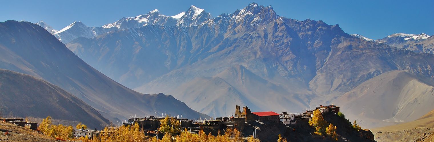
Instead of forests and waterfalls, you get a trans-Himalayan desert: eroded cliffs, deep canyons, dust, and open sky. Mustang sits in the rain shadow of Annapurna (8,091 m) and Dhaulagiri (8,167 m), so even during monsoon season, it stays unusually dry.

But wait, landscape isn’t the only reason why people love this region. Rather, it is the culture. Mustang was once the Kingdom of Lo. However, here is an interesting little detail: even after the abolition of the monarchy in 2008, the people in this region still follow the monarchical system, which is why the region is also known as the Hidden Kingdom of Nepal.
In fact, right till 1992, the whole area was closed to travellers. And that long isolation helped to preserve Tibetan Buddhist traditions, language, architecture, and everyday life patterns that have changed elsewhere.
This is not a “museum culture.” It is a living culture where monks, monasteries, festivals, prayer walls, and communities still operate in older rhythms.
Mustang attracts people who want something different: not summit drama, but cultural continuity and silence. Many trekkers describe it as two feelings at once: the shock of the desert landscape, and the calm of watching a society that has held onto its identity for centuries.
Quick Summary
- Mustang is a trans-Himalayan desert in Nepal’s rain shadow (drier even in the monsoon).
- Upper Mustang preserves Tibetan Buddhist culture strongly because it was closed to foreigners until 1992.
- Kagbeni (2,800 m) is the key dividing point between Lower vs Upper Mustang.
- Upper Mustang needs a Restricted Area Permit (USD 500/10 days + USD 50/day) and a licensed guide (min 2 trekkers).
- Best overall season is autumn (Sep–Nov); monsoon can work because of the rain shadow.
Where Exactly Is the Mustang Region Located?
Mustang District lies in Gandaki Province in northern Nepal. It covers 3,573 km² and had a population of 14,452 (2021 census). It stretches north to Nepal’s border with Tibet (China). Elevation ranges dramatically, from 1,372 m in the south to 8,167 m at Dhaulagiri. The inhabited parts of Upper Mustang typically sit between 2,800 m and 4,230 m.

The backbone of Mustang is the Kali Gandaki River, flowing south through the region. Between Annapurna and Dhaulagiri, the river cuts an extreme gorge (also described as the world’s deepest gorge) which reaches 5,571 m in vertical depth, where the riverbed sits around 2,520 m while the mountains rise beside it. Additionally, this corridor also acts as the main corridor that shapes travel routes, settlements, and the “map logic” of Mustang.
The climate is shaped by rain shadow geography. Monsoon winds drop most moisture on the southern slopes of the Himalayas. By the time air crosses to Mustang’s side, it has lost much of its moisture, creating an arid plateau environment. This is why Mustang can stay comparatively dry when other trekking regions are soaked.
Mustang location logic:
- Province: Gandaki Province
- Border: Tibet (China) to the north
- Key river corridor: Kali Gandaki
- Climate driver: Rain shadow effect
- Upper vs Lower transition point: Kagbeni (2,800 m)
What Is the Difference Between Upper Mustang and Lower Mustang?
Lower Mustang and Upper Mustang are not just “two halves of one district.” They feel like two different travel experiences. The transition point is Kagbeni (2,800 m). South of Kagbeni, the region is more accessible, with stronger roads and town infrastructure; north of Kagbeni, the landscape becomes more barren, higher, and more culturally “Tibetan” in tone.

The biggest practical difference is regulation. Upper Mustang is a restricted zone with a Restricted Area Permit (RAP), mandatory guide rules, and a minimum group size. Lower Mustang is more open, with standard trekking permits and easier access. This changes everything: cost, flexibility, comfort level, and how “remote” the experience feels.
So if your question is “Which Mustang is better?” it depends on what you want. Upper Mustang is the “preservation zone” and the strongest cultural immersion. Lower Mustang is a shorter, more affordable gateway with dramatic landscapes and major spiritual sites like Muktinath.
Upper vs Lower Mustang Comparison Table
| Dimension | Upper Mustang | Lower Mustang |
| Geographic scope | North of Kagbeni: Lo Manthang, Ghami, Tsarang, Chhoser | South of Kagbeni, Jomsom, Marpha, Muktinath, Lete, Tukuche |
| Permits | RAP + ACAP | ACAP + TIMS |
| Permit cost (non-resident) | USD 500 / 10 days + USD 50/day | Minimal (included via ACAP system) |
| Guide requirement | Mandatory licensed guide; solo prohibited | Solo trekking is allowed |
| Minimum group size | 2 persons or more | Any size |
| Access | Mainly trekking; limited jeep access beyond Kagbeni | Road, flight, and trekking |
| Culture level | Strong Tibetan language + traditions dominant | Mixed Tibetan/Thakali/Hindu influences |
| Commercial setup | Minimal; basic teahouses | More developed in the main towns |
| Landscape | High-altitude desert plateau; sparse vegetation | Gorge, river valley, agriculture mixed |
| Difficulty | Moderate (wind + altitude exposure) | Easy to moderate |
| Max elevation | 4,230 m (Marang La Pass) | 3,710 m (Muktinath area) |
Why Is Upper Mustang a Restricted Region?
Upper Mustang’s restricted status exists for stated policy reasons tied to preservation, security, and controlled development. One major reason is cultural: Upper Mustang’s identity is deeply Tibetan in language, religion, and lifestyle frameworks. The region stayed isolated for a long time (closed to foreigners until 1992), and that helped preserve cultural patterns that could change rapidly under unrestricted tourism pressure.

There is also a border factor. Upper Mustang touches Tibet (China), and the Kora La Pass (4,660 m) is an active crossing point. In border zones, foreign visitor movement is treated as sensitive. Permits and mandatory guides serve verification and monitoring functions.
Finally, there is a controlled tourism model. Instead of banning tourism, the system restricts access and uses a high permit fee to limit volume. In fact, the visitor numbers are limited to about 1,000 annually, with permit revenue (USD 500/10 days) supporting conservation and local development administered through ACAP.
Why restricted?
- Cultural preservation of Tibetan Buddhist identity and language
- Border sensitivity and monitoring near Tibet (China)
- Controlled tourism model (high fee limits volume)
- Infrastructure development historically limited; restrictions supported gradual development
What Permits Are Required to Visit the Mustang Region?
Permits depend on whether you are going to Upper Mustang (north of Kagbeni) or staying in Lower Mustang. Upper Mustang has a Restricted Area Permit (RAP) structure with strict rules. Lower Mustang follows standard Annapurna-region trekking requirements.
Upper Mustang requires:
- Restricted Area Permit (RAP): USD 500 per person for 10 days, then USD 50 per extra day. It is non-refundable, date-specific, and single-entry.
- ACAP permit: required as a conservation fee for the Annapurna region (including Upper Mustang).
- Guide requirement: mandatory licensed guide through a registered trekking agency; solo trekking prohibited; minimum group size 2.
Lower Mustang requires:
- ACAP permit
- TIMS card
Note: To get a permit, you need a registered trekking organisation. If you contact us, we can arrange any kind of trekking permits for you.
Permit Summary Box
| Region | Required permits | Guide rule | Solo trekking |
| Upper Mustang | RAP + ACAP | Mandatory licensed guide | Not allowed (min 2 persons) |
| Lower Mustang | ACAP + TIMS | Optional | Allowed |
How Difficult Is Trekking in the Mustang Region?
Mustang is often described as “easy to moderate,” but that can be misleading if people only think about altitude. The maximum elevation in Upper Mustang is 4,230 m (Marang La Pass), and most trekking happens around 2,800 m to 3,800 m. That is lower than some classic treks, but you stay at altitude consistently without much “relief,” which creates cumulative fatigue.
The bigger challenge is the environment. Wind is a real factor: afternoon winds average around 50 km/h and can gust higher, especially in spring. That wind does not usually make the route dangerous, but it makes trekking feel harder as the dust, cold, and mental exhaustion build up. The terrain is dry, rocky, dusty, with little shade, so dehydration and sun exposure become important even when temperatures feel cool.
So the honest answer is: it’s not technical climbing, but it is steady high-altitude walking with exposure. If someone expects green forests and soft trails, Mustang can feel tougher than expected, mainly psychologically and environmentally.
What Is the Best Time to Visit the Mustang Region?
Mustang is famous because it can work when other regions struggle. The rain shadow effect makes Upper Mustang comparatively dry even in the monsoon, so it becomes one of the rare places in Nepal where summer trekking can still be logical.
That doesn’t mean “no weather”, but it does mean the region does not follow the normal Nepal trekking calendar perfectly.

Spring (March–May) is clear and stable, and May includes the Tiji Festival in Lo Manthang. But spring is also the windiest time, with afternoon winds often exceeding 50 km/h. Autumn (September–November) is widely considered the best time for a balance of clear visibility, stable conditions, and more moderate winds. October is often cited as the “best single month.”
But here is the cool part: Monsoon (June–August) is a surprising option, with warmer temperatures and fewer crowds, and Upper Mustang stays far drier than Nepal proper. Winter (December–February) is harsh, with cold nights (-8 degrees Celsius or lower), possible snow disruptions, and reduced services due to local migration.
Month-by-month Mustang season
- Mar to Apr: Clear but windy
- May: Tiji Festival + warm days + very windy
- Jun to Aug: Rain shadow advantage; warmer; fewer crowds; dust storms possible
- Sep to Oct: Best balance; clear + moderate wind
- Nov: Stable, colder nights
- Dec to Feb: Extreme cold; limited services; experienced winter trekkers only
How Do You Reach the Mustang Region?
All routes to the Mustang region funnel through Pokhara and Jomsom. There is no direct Kathmandu-to-Upper Mustang connection without passing through these gateways.
Jomsom (2,740 m) is the main hub, with the district airport, accommodation, restaurants, market facilities, and basic hospital services. Flights to Jomsom typically operate early (around 7–9 AM) due to wind patterns. However, for afternoon flights, you need to realize that delays and cancellations are common, especially in the monsoon.
There are three practical access patterns: fast flights, full road travel, or mixed travel (fly in, trek out). Your decision usually depends on time, budget, and how much road fatigue you can tolerate. Road travel can be long (roughly 14–20 hours total), depending on vehicle type and breaks, while flights reduce travel time but add weather uncertainty.
After Jomsom, Upper Mustang can be reached by jeep (about 5–6 hours to Lo Manthang) or by trekking in 3–4 days via Jomsom, Kagbeni, Chele, Samar, and Lo Manthang.
Access Options
| Option | Route | Travel time | Best for | Main downside |
| Flight + Flight | KTM to Pokhara flight + Pokhara to Jomsom flight | 6 hours total travel | Fast access, less road fatigue | Weather delays/cancellations |
| Road Only | KTM to Pokhara and then to Jomsom by road | 14–20 hours | Budget + ground experience | Long, rough ride |
| Fly in + Trek return | Fly to Jomsom + jeep/trek to Lo + trek back | 18–20 days itinerary | Balance of speed + immersion | Longer overall trip |
What Kind of Culture and Lifestyle Exists in Mustang?
Mustang culture is not something “kept for tourists.” It is an active social system shaped by Tibetan Buddhism.
You will find a strong Sakyapa influence, where monasteries sit at the centre of community life. Places like Ghargumpa, Thubchen, Chode, and Jampa monasteries function as living religious institutions, not background monuments. The Tiji Festival in May is described as three days of masked dances (cham) centred on Chode Monastery, a spiritual practice that happens regardless of tourists.
Daily life carries visible religious elements: prayer flags across passes, mani walls lining trails, chortens standing as markers of faith. These are not “decor.” They structure how people move through space, even simple walking patterns (like circumambulating clockwise) follow religious logic.
The architecture and identity reflect climate and history. Houses are built low and clustered, with mud-brick walls and minimal windows for protection against wind and cold. In Lo Manthang, the walled city layout dates back to the 14th century and reflects both weather defence and trade-route security. Linguistically, many residents still speak Tibetic languages as their primary language, with Nepal’s national identity integration relatively recent (formal integration into Nepal’s federation after 2008).
Culture & lifestyle highlights
- Tibetan Buddhism shapes daily rhythm, ethics, and community structure
- Monasteries are active centers (education, ritual, gatherings)
- Tiji Festival (May) is a genuine spiritual event (masked dances)
- Traditional architecture built for wind/cold protection
- Tibetic languages remain primary in many communities
What Are the Main Places to See in the Mustang Region?
Mustang is not one attraction; it is a chain of places that each carries a different kind of meaning: political history (Lo Manthang), archaeology (Chhoser caves), spirituality (monasteries and pilgrimage sites), and geography (Kali Gandaki corridor). Many travellers come thinking “Upper Mustang = Lo Manthang,” but the region’s depth comes from how these sites connect.
Lo Manthang is often the centrepiece because it concentrates cultural and historical significance into a compact walled city. But surrounding areas add a different layer: caves carved into cliffs, ancient monasteries, and villages that act as thresholds between lower commercial towns and upper isolation.
Main places
- Lo Manthang (3,800 m): walled city; Royal Palace; Jampa, Thubchen, Chode monasteries
- Chhoser Caves (near Chhoser): multi-story cliff caves (Sija Jhong/Jhong Cave) with 40+ rooms; steep, physically demanding access
- Ghar Gompa (Lo Gekar Monastery, 3,920 m): ancient monastery linked to Guru Padmasambhava; important pilgrimage site
- Kagbeni (2,800 m): key checkpoint gateway to Upper Mustang; monastery; last major supply comfort point before deeper Upper Mustang
- Kali Gandaki River/Gorge: historic trade corridor; sacred shaligram fossils; defines the route structure
- Additional notable sites mentioned: Tsarang, Marpha, Muktinath Temple (3,710 m)
What Is Trekking Like Day to Day in Mustang?
Day-to-day life on the Mustang trek is shaped by cold mornings, strong afternoon winds, and simple lodging. Most days involve 5–7 hours of walking, but actual moving time may be 4–5 hours with breaks. Many trekkers prefer early starts because mornings are calmer; afternoons (roughly 12:00–3:00 PM) bring the strongest winds, dust, and solar exposure.
Accommodation is mostly teahouse-based in Upper Mustang. In smaller villages (Samar, Ghami, Charang), rooms are basic and unheated, with shared bathrooms and limited electricity (often solar/generator).
The warmest place is usually the communal dining room with a wood stove (bukhari). In bigger hubs (Jomsom, Kagbeni, Lo Manthang), lodging improves: private rooms sometimes exist, electricity and Wi-Fi may be available, and food choices expand, but it remains basic by international standards.
Food is simple and calorie-focused. Dal bhat is common. Fresh vegetables are seasonal and limited. Water is typically boiled for a fee, and many trekkers use purification tablets or filters to reduce plastic waste.
Day rhythm checklist
- Morning: cold start; breakfast; early walking
- Midday: lunch en route; wind rises
- Afternoon: dusty/windy; fatigue builds
- Evening: teahouse check-in; dinner; next-day briefing
- Night: cold rooms; blankets essential; early sleep
Is the Mustang Region Safe for Trekkers?
Mustang safety is mostly about managing altitude, wind exposure, and remoteness. Upper Mustang’s max altitude (4,230 m) is below the level where severe altitude illness is most common, but AMS symptoms are still possible, as 20–40% of visitors above 2,500 m may experience AMS symptoms (headache, nausea, fatigue, sleep disruption). Risk depends more on ascent speed and individual susceptibility than “how high the trek is.”
However, Wind is not an occasional problem; it’s a pattern. Gusts around 50 km/h are common, especially in spring afternoons. This typically causes fatigue, dust exposure, and heat loss rather than direct danger, but it demands proper wind layers and steady pacing.
Besides that, remoteness matters because evacuation is not instant. Helicopter evacuation depends on the weather. Jomsom has a district hospital with basic services, not advanced surgery capability, which is why travel insurance covering helicopter evacuation is mandatory for permit acquisition. Politically, the region is described as stable since its integration in 2008, with tourist crime incidents virtually unreported.
Safety risks
- Altitude: AMS possible; acclimatization + hydration matter
- Wind/exposure: physically and mentally tiring; dust + temperature swings
- Remoteness: medical access limited; evacuation weather-dependent
- Stability/crime: politically stable; crime against trekkers is rarely reported
Who Should and Should Not Visit the Mustang Region?
Mustang is not for everyone. This rain shadow valley works best for people who want culture and desert geography more than classic green trekking. It also works better for people with realistic expectations: basic accommodation, long walking days at altitude, and wind exposure.
For the right traveller, it can feel deeply meaningful: photographers love the desert light, culture travellers love the living monasteries, and repeat Nepal trekkers love how different it feels compared to Annapurna or Everest. But for budget travellers, luxury seekers, or first-time trekkers expecting “green Nepal,” Upper Mustang can feel particularly expensive and harsh.
Mustang fit guide
- Ideal for: repeat Nepal trekkers, culture travellers, photographers, spiritual seekers, solitude seekers, fit trekkers (5–7 hrs/day), flexible planners
- Not ideal for: first-time trekkers expecting greenery, strict budget travellers, luxury-first travellers, people uncomfortable with guide rules and restricted itineraries
What Trekking Packages Are Available in the Mustang Region?
Mustang has multiple trip styles, not just one “Upper Mustang trek.” Some people want the classic 14–15-day cultural circuit. Others want a short Lower Mustang experience. Some can’t trek long days and prefer jeep-based access. And some want to time the trip around the Tiji Festival.
Below are the package types available in the Mustang Region:
Mustang package types
- Upper Mustang Trek (14–15 days): classic Lo Manthang-focused trekking, caves + monasteries
- Lower Mustang Trek (7-12 days): Jomsom–Kagbeni–Muktinath options; shorter and more affordable
- Upper Mustang Jeep Tour (7–10 days): road-accessible culture + scenery; reduced walking
- Tiji Festival Trek (14–16 days, mid-May): festival-centred itinerary in Lo Manthang
- Upper Mustang + Annapurna combo (18–24 days): desert + alpine ecosystems in one longer trip
- Ghar Gompa trek (12–14 days): less-visited routes + monastery emphasis
- Upper Mustang luxury camping (14–15 days): private camp infrastructure instead of teahouses (high-end style)
Frequently Asked Questions About Mustang Region Nepal
Can I trek Upper Mustang solo?
No. Upper Mustang requires a minimum group of 2 people and a government-licensed guide through a registered agency. Lower Mustang allows independent trekking.
Is my permit checked on the trail?
Yes. Checkpoints exist at Kagbeni (entry), Charang (mid-route), and Lo Manthang (destination). Guide credentials and permit dates are verified.
Is Mustang expensive compared to other Nepal treks?
Upper Mustang is more expensive mainly because of the USD 500 minimum permit. Lower Mustang is far more affordable.
Is Wi-Fi available in Mustang?
Inconsistent. Jomsom, Kagbeni, and Lo Manthang may have Wi-Fi in some lodges, but it is often unreliable. Smaller villages usually do not have Wi-Fi.
How cold does it get in Mustang?
Around 3,000–3,800 m, daytime can be roughly 5–15°C depending on season; nights often range from –8°C to –2°C, colder in winter.
Is Upper Mustang worth the USD 500 permit cost?
It depends. For culture-focused travellers, photographers, and repeat Nepal trekkers, the combination of preserved Tibetan Buddhist culture and trans-Himalayan desert geography is unique. For strict budget travellers or those chasing green landscapes and peak views, it may not feel worth it.
Is the Mustang Region Worth Visiting?
Mustang is worth it when you want what Mustang actually offers, not what people expect Nepal to offer. It is a dry, trans-Himalayan desert landscape inside Nepal, shaped by rain shadow geography, and it holds a Tibetan Buddhist cultural continuity that survived because the region stayed isolated for decades. That combination is rare.
But it also asks something from the trekker: acceptance of wind, dust, basic lodging, and steady days at altitude. Upper Mustang adds a serious permit cost, strict guide rules, and controlled access. Those restrictions exist as preservation and monitoring tools in a sensitive and fragile region.
If you’re a traveller who values authenticity over comfort, culture over spectacle, and silence over crowds, Mustang can feel unforgettable not because it is the “highest” trek, but because it shows how humans have lived, adapted, and stayed spiritually rooted in a harsh landscape for centuries.