Lower Mustang Trek
TripAdvisor Reviews Recommended by 99.99% travelers
USD 1500
Nepal
12 Days
Moderate
3,762 m / 12,343 ft at Muktinath
Hotels and Teahouses
Car / Bus / Jeep
1-20
Spring
- Walk through Nepal’s trans-Himalayan desert landscape shaped by wind, rock, and open skies.
- Trek in the rain shadow of Annapurna and Dhaulagiri with minimal monsoon rainfall.
- Visit Muktinath Temple at 3,710 meters, sacred to both Hindus and Buddhists.
- Explore Kagbeni, the medieval gateway village to Upper Mustang.
- Walk along the Kali Gandaki River, the world’s deepest gorge.
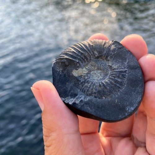
- Search for sacred Saligram fossils along ancient riverbanks.
- Experience authentic Thakali culture, food, and village life.
- Visit Marpha, famous for apple orchards and traditional brandy.
- Travel through lesser-visited Mustang villages by road.
- Avoid restricted-area permits required for Upper Mustang.
- Trek at moderate altitude with reduced risk of altitude sickness.
- Stay in traditional teahouses and local lodges.
- Suitable for first-time Himalayan trekkers with basic fitness.
- Ideal for cultural travelers and photographers.
- One of the few Himalayan treks possible during monsoon season.
Lower Mustang Trek Overview
Lower Mustang is one of Nepal’s most culturally distinct trekking regions, located in a dry, high-altitude Himalayan region shaped by Tibetan Buddhism, ancient trade routes, and sacred pilgrimage sites. Because it sits in the rain shadow of Annapurna and Dhaulagiri, it receives far less monsoon rain, making it one of the rare treks that can still work in June–August when many other routes are wet and cloudy.
Unlike Upper Mustang, Lower Mustang is not a restricted area, so you don’t need the expensive USD 500 permit or compulsory restricted-area rules. Furthermore, it is the trek that acts as your first introduction to the Mustang region. But here is the cool part: You still get the atmosphere: medieval villages, monasteries, Tibetan-style architecture, and Muktinath, but with simpler logistics and a much more realistic budget.
Still not convinced? Wait, let us tell you why the Lower Mustang trek is worth it!!
What Makes Lower Mustang Different
1) Rain-shadow “Himalayan desert” feel
You’ll notice it fast: drier air, dusty trails, wind-sculpted landscapes, and big open valleys that feel closer to the Tibetan Plateau than the green Annapurna foothills.
2) Cultural depth without restricted-area rules
Lower Mustang gives access to Tibetan Buddhist culture (plus Thakali, Gurung, Magar influences) without requiring the costly Upper Mustang restricted permit.
3) Kagbeni’s medieval village exploration
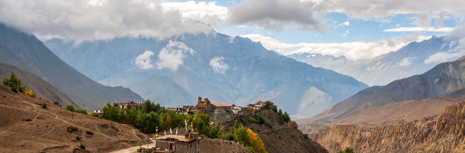
Kagbeni is a true architectural time capsule where you will find narrow stone lanes, fortress-style layout, and the famous checkpoint that marks the boundary toward Upper Mustang.
4) Muktinath’s dual sacredness
At 3,710 m, Muktinath is sacred for both Hindus and Buddhists. The 108 water spouts and the eternal flame create an experience that feels like more than “just trekking.”

5) Opportunity to try Apple Products of Marpha
Marpha is known for orchards, apple products, and its famous local brandy culture. In fact, it is a very “Mustang” style highlight that most other regions don’t have.
6) Saligram (Shaligram) fossils in Kali Gandaki
Kali Gandaki is known for black spiral fossils (ammonites) revered by Hindus and used by Buddhists. Many trekkers enjoy searching riverbanks, and if you are luck,y you will find one as well.
Who This Trek Is For (and Who It Isn’t)
Lower Mustang suits trekkers who want a moderate Himalayan trek without extreme altitude exposure. With a maximum elevation of 3,710 meters and overnight stays mostly below 3,000 meters, it works well for first-time Himalayan trekkers who are reasonably fit and able to walk 4–6 hours a day.
It is particularly rewarding for travellers interested in Tibetan Buddhism, pilgrimage culture, and village life. Places like Kagbeni, Muktinath, and Marpha offer daily interaction with living traditions rather than staged cultural displays.
However, this trek is not ideal for trekkers seeking pristine wilderness throughout. Dirt roads run alongside parts of the trail, and strong afternoon winds are part of daily life in the Jomsom valley. Those expecting luxury accommodation or untouched backcountry solitude may find other routes more suitable.
- Day 1: Arrival in Kathmandu (1350 m / 4430 ft)
- Day 2: Drive from Kathmandu to Pokhara (827 m/2,713 ft)
- Day 3: Drive From Pokhara To Tatopani (1,190 m / 3,904 ft)
- Day 4: Drive from Tatopani to Jomsom (2,736 m / 8,976 ft)
- Day 5: Trek From Jomsom to Kagbeni (2,858 m / 9,377 ft)
- Day 6: Kagbeni Exploration Day (2,858 m / 9,377 ft)
- Day 7: Trek From Kagbeni To Jharkot (3,550 m / 11,647 ft)
- Day 8: Visit Muktinath and Back to Kagbeni
- Day 9: Trek Back to Jomsom via Lupra Village
- Day 10: Drive from Jomsom to Pokhara
- Day 10: Drive From Pokhara To Kathmandu
- Day 12: Departure from Kathmandu
Detailed Itinerary
Day 1: Arrival in Kathmandu (1350 m / 4430 ft)
Trek Distance
6 to 7 km
Highest Altitude
1,350 m / 4,430 ft (TIA runway)
Trek Duration
1-3 hours
Meals
Breakfast
After a long flight from your home country, you finally land in Kathmandu, the capital city of Nepal. As your flights land, you will exit via the bus provided by the Tribhuvan International Airport (Tribhuvan International Airport).
From then on, you have to fill in the arrival cards and stand in the queue for the Visa on Arrival. After passing immigration and collecting your baggage, you will find our team waiting for you with a name card at the entrance to TIA.
We will then transfer you to your hotel in Thamel. The drive from the airport to Thamel is about 6 km and takes 20 to 30 minutes, depending on traffic.
However, during the peak hour (10 am to 8 pm), the drive can take around 90 minutes.
After reaching your hotel, you can rest to get over that jet lag. In the evening, we will arrange a brief meeting with your guide, who will give a 30 to 45-minute session. In that session, he will cover:
- Route map review (Pokhara/Beni/Jomsom key points)
- Daily elevations/AMS risks
- Quick Gear Check
- Permit Display
Note: Depending upon your flight timing, this quick session can be done the next day as well.
Once this is done, we’ll call it a day and we’ll prepare ourselves for next day drive from Kathmandu to Pokhara.
Day 2: Drive from Kathmandu to Pokhara (827 m/2,713 ft)
Trek Distance
110 km / 68 miles
Highest Altitude
1,500 m / 4,921 ft (Nagdhunga Pass)
Trek Duration
6–9 hours driving
Meals
Breakfast/Lunch/Dinner
The second day starts early, as today we are going to take a long 6 to 9-hour drive from the capital to Pokhara. During this journey to western you can see a clear terrain shift from urban outskirts to hilly highways.
However, this drive can be mentally demanding due to the current road conditions of the Tribhuvan Highway. Furthermore, an early departure is essential to avoid daytime road closures and peak traffic on the Kathmandu–Mugling section.
Talking about the drive itself, it starts from Kathmandu, exiting the valley via the Tribhuvan Highway toward Nagdhunga Pass (1,500 m).
After crossing Sisnekhola and Khanikhola between Nagdhunga and Naubise, the route joins the Prithvi Highway at Naubise. From here, the road closely follows the Trishuli River through Kurintar, Galchhi, Malekhu, Benighat, and descends to Mugling, the lowest point of the day.
From Mugling, the route turns west, climbing gradually through Dumre, Damauli, and Anbukhaireni along the Marsyangdi River before the final approach to Pokhara, where the Seti River appears near the city.
However, as we already told you, the Kathmandu–Mugling section has mixed road conditions with active construction zones and possible daytime closures between 10:30 AM and 3:00 PM.
Additionally, the heavy traffic in this area is common, especially near the Mugling junction. Starting between 5:00 and 6:00 AM significantly reduces delays.
But as you reach Pokhara, you will find all the comforts that the tourist capital of Nepal offers, reliable accommodation, hot showers, and access to trekking shops for final preparations.
Day 3: Drive From Pokhara To Tatopani (1,190 m / 3,904 ft)
Trek Distance
100 km / 62 miles
Highest Altitude
1,190 m / 3,904 ft (Tatopani)
Trek Duration
6-7 hours driving
Meals
Breakfast/Lunch/Dinner
Okay, this is going to be another full road travel day that moves the group from Pokhara into the Kali Gandaki corridor. The first part is fast and smooth, then the road conditions become more mixed after Beni. You can expect about 6–7 hours of driving on the road, with short tea or meal stops.
The effort is passive, but the day can feel long due to vehicle movement, bends, and occasional rough patches.
After leaving Pokhara (827 m), the route follows the Pokhara–Beni Highway for roughly 110 km, passing the Phewa Lake area, terraced fields, small rural settlements, and Dhikur Pokhari before reaching Beni junction (600 m). From Beni, the road turns onto the Beni–Tatopani section (30 km), where the Kali Gandaki River becomes the main reference point as the road climbs to Tatopani (1,190 m).
But the good news is Pokhara–Beni side’s road is blacktopped and reliable. However, after Beni, expect some unpaved stretches; high clearance helps, and during the monsoon landslides can slow progress.
Day 4: Drive from Tatopani to Jomsom (2,736 m / 8,976 ft)
Trek Distance
49 km / 30 miles
Highest Altitude
2,743 m / 8,999 ft (Jomsom)
Trek Duration
5-6 hours driving
Meals
Breakfast/Lunch/Dinner
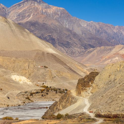
This is going to be the final road day before you start your trek. And it is a long uphill drive that transitions from the warm river valley at Tatopani into the upper Kali Gandaki corridor. Road conditions here change quickly. For example, the first section is mixed, then the track becomes rough and slow after the gorge narrows.
You can expect 5-6 hours total on this road, including short meal stops. The effort is passive, but the day can feel demanding due to continuous bumps, water crossings in wet periods, and limited services between settlements.
During the drive from Tatopani (1,190 m), the vehicle follows the Kali Gandaki River upstream toward Ghasa (2,010 m). In this section, the route passes through the Kali Gandaki Gorge between Dhaulagiri (8,167 m) and Annapurna (8,091 m) and reaches the Rupse Waterfall area. From Ghasa, the drive continues up-valley to Marpha (2,670 m), then follows the final valley road into Jomsom (2,743 m), Mustang’s district hub near Jomsom Airport.
Since the car or tourist bus isn’t feasible, for this section we will opt for a 4WD jeep. With that, you will also get an experienced driver for the Tatopani–Ghasa and Ghasa–Marpha sections. The uneven surfaces and seasonal mud of the route demand some level of experience. Furthermore, since winds in the Kali Gandaki corridor strengthen later in the day, which means an early departure is a must in these areas.
Day 5: Trek From Jomsom to Kagbeni (2,858 m / 9,377 ft)
Trek Distance
11 km / 7 miles
Highest Altitude
2,858 m / 9,377 ft (Kagbeni)
Trek Duration
3.5–4 hours
Meals
Breakfast/Lunch/Dinner
Finally, we start our first trekking day, which is short and deliberately kept easy. In fact, we kept it in such a way to support acclimatization after arriving in Jomsom.
The walk in itself is gentle, with minimal elevation gain of 138 m, and follows the wide floor of the Kali Gandaki valley. Walking time is usually 3.5–4 hours at a relaxed pace. And the terrain is mostly flat, with a mix of newly built dirt roads and established foot trails. Although physically undemanding, afternoon winds and dust can add mild discomfort if the day starts late, so an early departure is recommended.
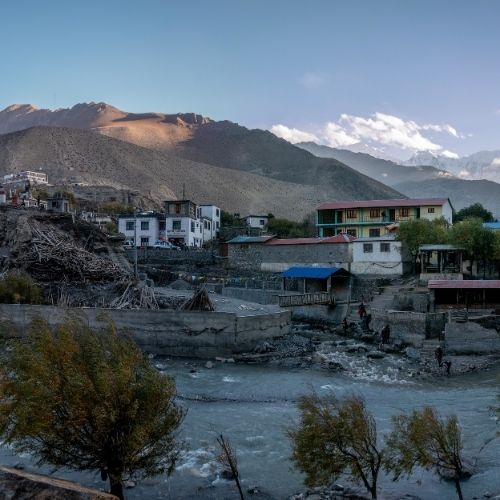
Talking about our route, it begins from Jomsom town and airport area (2,720 m), heading north–northeast along the west bank of the Kali Gandaki River. The trail follows the river corridor toward Ekle Bhatti, a small settlement reached after about 4–5 km. This is a common tea stop before continuing deeper into the valley. Beyond Ekle Bhatti, the gorge gradually narrows, with red rock formations becoming more prominent. The route remains clear and straightforward, staying close to the river with no major junctions. As Kagbeni approaches, the Jhong Khola tributary becomes visible, and the village’s monastery structures can be seen ahead. The trail then enters Kagbeni through narrow village lanes.
However, we need to remember that Jomsom is known for strong afternoon winds moving up the Kali Gandaki gorge. This is why starting between 7:00 and 7:30 AM helps avoid the worst conditions. Dust from occasional vehicles is common on the first section, especially in dry seasons. Kagbeni is also a permit checkpoint, so documents should be accessible on arrival.
Day 6: Kagbeni Exploration Day (2,858 m / 9,377 ft)
Trek Distance
N/A
Highest Altitude
2,858 m / 9,377 ft (Kagbeni)
Trek Duration
4-5 hours
Meals
Breakfast/Lunch/Dinner
To fully understand the mustang region, one full cultural exploration day based entirely in and around Kagbeni is essential. This day is just that!
On this day, physical effort is moderate and flexible, combining slow village walking with an optional half-day hike to nearby settlements.
The whole terrain includes compacted village paths, narrow medieval lanes, and well-established trails along the Kali Gandaki river corridor. There is no time pressure today, and activities can be adjusted based on energy levels and weather conditions.
Kagbeni Village Exploration (Morning)
The morning is spent inside Kagbeni village, one of the oldest continuously inhabited settlements in the Kali Gandaki valley. Walking through narrow lanes reveals traditional mud-brick houses, enclosed courtyards, prayer wheels, chortens, and defensive tunnel-like passages that reflect Kagbeni’s medieval fortress design.
The primary cultural site is Kag Chode Thupten Samphel Ling Monastery, founded in 1429 and still active today. Inside the main prayer hall are Buddhist statues, thangka paintings, wall frescoes, and carved wooden elements.
Nearby are the Kheni guardian figures at the old village gates, representing pre-Buddhist protective beliefs, and the Devthen Chhorten, a small shrine attributed to Guru Rimpoche. The Kag Khar Palace ruins, once part of a fortified trade stronghold on the salt route to Tibet, are visible throughout the village layout. A short walk also leads to Pitri-Moksastala, the Hindu ritual site at the confluence of the Kali Gandaki and Jhong Khola rivers.
Optional Day Hike: Kagbeni To Tangbe To Chhusang
After village exploration, an optional hike follows the west bank of the Kali Gandaki River northward. The trail first reaches Tangbe village (approx. 2,800 m), passing open riverbeds, sparse juniper vegetation, and canyon walls rising between Dhaulagiri (8,167 m) and Annapurna (8,091 m). From Tangbe, the trail continues gradually uphill to Chhusang (approx. 2,980 m), where red cliff formations dominate the gorge landscape. The route uses established hiking paths and occasional riverbed sections before returning the same way to Kagbeni.
Things To Remember Today
Morning conditions are calmer; winds usually strengthen in the afternoon. Water is available in teahouses, but carrying sufficient supplies is recommended. Slow pacing is important even on easy terrain to support acclimatization.
Day 7: Trek From Kagbeni To Jharkot (3,550 m / 11,647 ft)
Trek Distance
6.5 km / 4 miles
Highest Altitude
3,550 m / 11,647 ft (Jharkot)
Trek Duration
3.5–4 hours walking
Meals
Breakfast / Lunch / Dinner
Today is going to be one of the most difficult days of the trek as it is a sustained uphill trekking day, with a steady gain in altitude from Kagbeni to the ridge-top village of Jharkot.
Although the distance is short, the elevation gain is of around 715 m, which is significant, and the effort level is moderate to demanding. The trail climbs continuously with no meaningful descent, so a slow, even pace is important.
Talking about the terrain, it is going to be dry and exposed, typical of Lower Mustang, with increasing altitude effects felt in the final section.
The trek starts from Kagbeni village center (2,858 m), heading north to northeast away from the Kali Gandaki river corridor. The initial section follows stone village paths and cultivated fields, running alongside small irrigation channels that supply water to Kagbeni.
As the trail leaves the village behind, it enters open hillside terrain, climbing steadily on a well-defined footpath of packed earth and loose stones. With height, the landscape becomes more arid, and views open back toward the Kali Gandaki valley.
Midway, the ascent steepens, and prayer stones and chortens begin to appear, marking the approach to higher Buddhist settlements. Jharkot becomes visible ahead on a raised ridge. The final climb is the steepest part of the day before the trail enters the narrow lanes of Jharkot village.
From the trail, clear views extend toward Nilgiri, Annapurna, and Dhaulagiri, while the village itself is dominated by traditional mud-brick houses and its historic monastery.
Furthermore, cold air and thinner oxygen are noticeable on arrival, which makes rest and hydration important in the afternoon.
Day 8: Visit Muktinath and Back to Kagbeni
Trek Distance
20 km / 12 miles
Highest Altitude
3,762 m / 12343 ft (Muktinath)
Trek Duration
4–5 hours
Meals
Breakfast/Lunch/Dinner
Today is the spiritual and emotional high point of the Lower Mustang journey. You leave Jharkot in the morning, climb gently toward Muktinath Temple, the most sacred pilgrimage site in the region, and then make a long downhill return to Kagbeni. The day combines belief, landscape, altitude exposure, and a dramatic descent back into the Kali Gandaki corridor, which means it is going to be a difficult day for your legs.
Jharkot to Muktinath: Morning Ascent
The day begins with a short but meaningful uphill walk from Jharkot. Leaving the village, the trail heads north-northwest, climbing gradually across open, arid slopes typical of the Muktinath valley. Stone village paths slowly give way to a clear trekking trail marked by chortens, prayer flags, and mani walls, signalling the approach to a sacred zone.
As you gain height, the terrain opens completely. There is little vegetation here. In fact, you will only find dry earth, scattered rocks, and an immense sky. The Muktinath temple complex and Ranipauwa settlement soon become visible ahead, sitting proudly beneath the mountains.
On clear mornings, views extend toward Nilgiri, Dhaulagiri, and parts of the Annapurna range, making the walk calm rather than physically demanding.
Muktinath Temple Experience
Muktinath sits at the foot of the Thorong La region and holds deep meaning for both Hindus and Buddhists. Inside the complex, you move between the main Vishnu shrine, the famous 108 water spouts, sacred ponds, and the eternal flame that burns naturally from underground gas. The atmosphere is active yet reverent, shared by pilgrims, monks, and trekkers alike.
Spending time here also serves as gentle acclimatization at the highest point of the trek.
Descent from Muktinath to Kagbeni
In the afternoon, the route turns south and southwest for a long descent. The trail drops steeply at first, passing below Ranipauwa and toward the Khingar and Jhong areas, where the valley begins to widen.
With every step down, the landscape changes subtly, the air thickens, the slopes soften, and the sense of moving back into a river system becomes clear.
Lower down, the Kali Gandaki valley dominates the view. The trail funnels naturally toward Kagbeni, following the logic of the gorge carved between Annapurna and Dhaulagiri.
By the time you reach the village, prayer flags, flat-roofed houses, and the river’s combination welcome you back to familiar ground.
Then in the evening, Kagbeni feels warmer, quieter, and deeply grounded after the sacred intensity of Muktinath. This day is remembered not for distance, but for meaning; the moment where landscape, faith, and the journey itself fully come together.
Day 9: Trek Back to Jomsom via Lupra Village
Trek Distance
13 km / 8 miles
Highest Altitude
2,858 m / 9,377 ft (Kagbeni)
Trek Duration
4-6 hrs
Meals
Breakfast / Lunch /Dinner
You leave Kagbeni early and climb away from the Kali Gandaki corridor, angling toward the ridgeline that leads to Lupra Pass. The route here is simple but demanding: you rise steadily onto open, barren slopes, the trail tightening into a steeper push as the pass comes into view. However, the scenery feels bigger with every step as it is combined with wide sky, raw rock, and a growing sense of exposure.
From the pass, you drop into the Panda Khola valley, following the gorge line down toward Lupra, Mustang’s rare surviving Bon village. The descent is rocky in places, but culturally rich. Here you will find quiet homes, a distinct spiritual identity, and a monastery atmosphere that feels older than the trekking trail itself.
After Lupra, the route continues down through traditional settlements and orchard country, gradually returning you to the wider valley floor as you approach Jomsom, usually before the strongest afternoon winds peak.
Day 10: Drive from Jomsom to Pokhara
Trek Distance
160 km / 99 miles
Highest Altitude
2,743 m / 8,999 ft (Jomsom)
Trek Duration
7–9 hrs
Meals
7–9 hrs
Now, since our trekking days are far behind we will begin our journey back to Pokhara.
The drive leaves Jomsom following the Kali Gandaki valley, descending steadily through Marpha, Tukuche, Tatopani, and Beni.
During the drive, you will see terrain shifts from dry trans-Himalayan landscape to forested mid-hills after Tatopani.
Here you will find rough sections, dust, and slow traffic in places. Arrival in Pokhara feels noticeably warmer and more relaxed.
Day 10: Drive From Pokhara To Kathmandu
Trek Distance
200 km / 124 miles
Highest Altitude
1,350 m / 4,429 ft (Kathmandu)
Trek Duration
6–8 hrs
Meals
Breakfast /Dinner
The drive follows the Prithvi Highway, running alongside the Marsyangdi and Trishuli rivers through the mid-hill corridor.
The road alternates between river valleys, small towns, and terraced hillsides, with increasing traffic closer to Kathmandu. It is a long but straightforward travel day with regular stops.
In the evening, a farewell dinner marks the end of the journey, allowing time to reflect on the route from Mustang back to the capital. Furthermore, we will also provide you with the certificate of completion as you finish this deeply meaningful journey.
Day 12: Departure from Kathmandu
Trek Distance
N/A
Highest Altitude
1,350 m / 4,429 ft (Kathmandu)
Trek Duration
N/A
Meals
Breakfast
This is a non-trekking day. Depending on flight time, there may be an early transfer to Tribhuvan International Airport.
Morning traffic in Kathmandu can be unpredictable, so departures are planned with buffer time. Assistance is provided for airport procedures before final departure.
YOUR LOWER MUSTANG JOURNEY FINALLY ENDS HERE!!
Cost Includes
- Airport pickup and drop-off in Kathmandu by private vehicle
- Hotel transfers in Kathmandu and Pokhara as per itinerary
- All ground transportation mentioned in the itinerary
- Hotel accommodation in Kathmandu and Pokhara on a twin-sharing basis
- Teahouse or lodge accommodation during the trek
- Accommodation arranged on a full-board trekking basis
- Drive from Kathmandu to Pokhara by tourist bus or private vehicle
- Drive from Pokhara to Tatopani
- Drive from Tatopani to Jomsom
- All required local jeep or road transfers during the trek
- Optional domestic flight assistance (if chosen instead of road, at extra cost)
- Annapurna Conservation Area Permit (ACAP)
- TIMS Card (Trekkers’ Information Management System)
- All necessary government taxes and service charges
- Government-licensed, experienced trekking guide
- Guide’s salary, accommodation, meals, insurance, and equipment
- Porter service (if booked), including porter salary, meals, insurance, and gear
- One porter for two trekkers (standard load limit respected)
- Three meals per day during trekking days (breakfast, lunch, dinner)
- Freshly cooked meals at teahouses
- A cup of tea or coffee is provided daily during trekking hours
- Fresh seasonal fruits are served after dinner during the trek
- Basic first aid medical kit carried by the guide
- Oximeter for altitude monitoring
- Emergency support coordination if required
- Guided visit to Muktinath Temple
- Cultural walks through Kagbeni, Marpha, and traditional villages
- Exploration of lesser-known settlements accessible via road route
- Local cultural interpretation by experienced guide
- Lower Mustang Trek completion certificate
- All administrative and operational support from Eco Nepal Trekkers
Cost Excludes
- International airfare to and from Nepal
- Domestic flights (Pokhara–Jomsom–Pokhara) if chosen instead of road travel
- Nepal entry visa fees
- Travel insurance (must cover high-altitude trekking and helicopter evacuation)
- Lunch and dinner in Kathmandu and Pokhara
- Any meals not mentioned under “Cost Includes”
- Hot showers, Wi-Fi, and device charging at teahouses
- Bottled drinks, snacks, chocolates, or alcoholic beverages
- Personal shopping, souvenirs, and bar bills
- Personal trekking equipment and clothing
- Sleeping bag and down jacket (can be rented if needed)
- Trekking poles, backpacks, or personal medical supplies
- Tips for guide and porter (recommended but not mandatory)
- Helicopter evacuation and medical expenses
- Extra accommodation or meals due to weather delays or itinerary changes
- Costs arising from natural disasters, landslides, flight cancellations, or political disturbances
- Any services not specifically listed under “Cost Includes”
Useful Information
How Difficult Is Lower Mustang Trek?
Lower Mustang is best described as moderate, but that term hides important realities. While technical climbing skills are not required, the dry climate, constant wind, and sustained walking days create fatigue that no other trekking experience in Nepal can provide.
Most days involve 3–7 hours of walking on uneven terrain at elevations between 2,500 and 3,700 meters. The altitude is manageable, but trekkers still feel reduced oxygen levels, particularly on climbs toward Muktinath and high passes near Lubra.
Trekkers should be comfortable walking several hours daily while carrying a daypack. Prior hiking experience is helpful but not mandatory if proper preparation is done.
What Are the Real Altitude Risks And How To Remain Safe During Lower Mustang Trek?
Although Lower Mustang stays below 4,000 meters, altitude effects still occur. Mild headaches, breathlessness, and sleep disturbance are common around Muktinath and Jharkot.
Which is why we created an itinerary that minimizes risk by following gradual ascent profiles and using a “climb high, sleep low” approach.
Furthermore, during the trek, our guides monitor symptoms closely, and helicopter evacuation is available if required, provided trekkers have appropriate insurance coverage.
Besides that, Lower Mustang’s road access and village network also mean help is closer compared to more remote treks, adding an extra layer of safety.
Best Time to Trek Lower Mustang
Lower Mustang can be trekked almost year-round, but conditions vary by season.
Spring (March–May) and autumn (September–November) offer the best visibility and stable weather, which means these are the absolute best times to visit.
Summer months remain surprisingly dry due to the rain shadow, making Lower Mustang one of Nepal’s best monsoon trekking options. Winter trekking is possible but demands cold-weather experience.
What Kind Of Accomodation And Meals Will You Get During Lower Mustang Trek?
Accommodation follows Nepal’s teahouse system. Rooms are simple, usually twin-shared, with basic bedding and shared bathrooms. Heating is limited to communal dining areas, and nights can be cold, especially in spring and autumn.
Meals are freshly prepared and carb-focused. Dal bhat forms the nutritional backbone of the trek, supported by soups, noodles, momos, and simple egg dishes. Vegetarian food is strongly recommended at higher elevations due to refrigeration limitations.
Villages like Jomsom and Marpha offer slightly better lodge standards, while places such as Lubra provide homestay-style accommodation with minimal facilities but deep cultural immersion.
Permits Required for Lower Mustang Trek
Lower Mustang requires only standard trekking permits. Trekkers must obtain:
- The Annapurna Conservation Area Permit (ACAP)
- TIMS card.
No restricted-area permit is required, and independent trekking is legally allowed, though guides are strongly recommended for safety and cultural understanding.
Packing List for Lower Mustang Trek
Packing for the Lower Mustang Trek requires a slightly different mindset than packing for routes like Annapurna Base Camp or Everest Base Camp. While altitude is lower and rainfall is minimal, the region presents its own challenges: strong daily winds, dust from dirt roads, intense sun exposure, and cold nights in unheated lodges.
Lower Mustang sits in the rain shadow of the Annapurna and Dhaulagiri ranges. This means you will deal far less with rain and mud, but far more with dry air, wind chill, and airborne dust, especially in the Jomsom–Kagbeni–Marpha area. Afternoon winds are not occasional, they are a daily pattern, and poor packing choices can quickly turn a comfortable trek into a frustrating one.
The list below focuses only on what actually matters for Lower Mustang, not a generic Himalayan packing list.
Clothing: Dressing for Wind, Sun, and Cold Nights
Layering is essential, but unlike wetter treks, wind protection and sun defense are more important than rain resistance.
Base Layers (Moisture & Temperature Control)
- 2 sets of thermal base layers (top and bottom)
Merino wool or synthetic fabrics are ideal. Even in spring and autumn, mornings and nights can be freezing, while days warm quickly. - 4–6 pairs of trekking socks (wool or wool-blend)
Dry air helps socks dry faster, but cold mornings make warm socks essential.
Mid Layers (Insulation)
- 1 fleece jacket or pullover
Used daily in the mornings and evenings. - 1 insulated down or synthetic jacket (with hood)
Crucial for cold evenings in lodges where rooms are unheated. - Optional: fleece or insulated pants
Very useful in winter and for people sensitive to cold.
Outer Layers
- Windproof jacket (critical item)
This matters more than waterproofing in Lower Mustang. Afternoon winds are strong and persistent. - Lightweight waterproof shell (optional but recommended)
Useful for shoulder seasons or unexpected weather, but not the primary defense.
Trekking Clothes
- 2–3 pairs of quick-dry trekking pants
Avoid heavy fabrics; dust sticks to cotton. - 3–4 moisture-wicking trekking shirts (mix of short and long sleeve)
- Warm beanie or wool hat
- Wide-brim sun hat or cap
- Buff or neck gaiter
This doubles as sun protection, wind barrier, and dust mask. - Lightweight gloves (plus insulated gloves in winter)
Footwear
- Well-broken-in trekking boots (ankle support recommended)
Lower Mustang trails include gravel paths, dry riverbeds, and uneven stone steps. - Camp shoes or sandals
Essential for lodge evenings and cold bathroom trips.
Dust & Wind Protection (Lower Mustang–Specific Essentials)
This is where Lower Mustang differs most from other treks.
- Dust mask or N95-style mask
Strongly recommended. The Jomsom valley experiences daily dust storms due to wind and vehicle movement. - Sunglasses with full UV protection
Sun intensity is high, and dust can irritate eyes. - Lip balm with SPF
Dry air causes cracked lips quickly. - High-SPF sunscreen (SPF 50+)
UV exposure is stronger in the trans-Himalayan zone than in forested treks. - Moisturizer
Skin dries out rapidly due to wind and low humidity.
Backpack & Luggage Strategy
If Using a Porter
- Large duffel bag (70–90L) for porter
- Daypack (20–30L) for daily essentials
If Trekking Without a Porter
- Backpack (40–50L max)
- Pack weight ideally under 12–15 kg
Pack everything in dust-resistant or waterproof inner bags, as fine dust gets into zippers and fabric easily.
Sleeping & Lodge Comfort
- Sleeping bag rated to at least -10°C
Even in spring and autumn, nights in places like Jharkot and Marpha can be cold. - Optional sleeping bag liner
Adds warmth and improves hygiene.
Trekking Gear That Actually Helps
- Trekking poles
Extremely useful on long descents and gravel trails. - Headlamp with spare batteries
Power cuts are common; bathrooms are often outside. - Reusable water bottles (2 × 1 liter)
Boiled water is available at lodges. - Water purification tablets or filter
Useful between villages.
Health, Hygiene & First Aid
Lower Mustang is dry and windy, which affects the body differently than humid treks.
- Basic first-aid kit (blister care, painkillers, bandages)
- Personal medications (bring extra days’ supply)
- Altitude medication if prescribed (e.g., Diamox)
- Hand sanitizer and wet wipes
Showers are limited; wipes are often more practical. - Toilet paper (not always provided)
- Small towel (quick-dry)
Electronics & Documents
- Power bank (20,000 mAh or higher)
Charging costs extra and electricity can be unreliable. - Phone/camera + extra batteries
Cold drains batteries quickly. - Copies of passport, permits, and insurance
- Cash in small denominations (ATMs are unreliable)
Seasonal Add-Ons
Spring & Autumn
- The standard list above is sufficient
Summer (Monsoon Elsewhere, Not Here)
- Light rain jacket
- Extra sun protection
- Dust mask becomes even more important
Winter (December–February)
- Heavier down jacket
- Thicker gloves and thermal layers
- Sleeping bag rated to -15°C or lower
- Chemical hand/foot warmers (optional)
Transportation In Lower Mustang Trek
Most Lower Mustang itineraries rely heavily on flights—especially the short but weather-sensitive flight between Pokhara and Jomsom. While flying is faster, our Lower Mustang Trek is intentionally designed as a road-based journey, because we believe the approach matters just as much as the destination.
The trek begins with a drive from Kathmandu to Pokhara, following Nepal’s central river valleys and mid-hill settlements. This route offers a gradual transition from the capital’s busy life into the quieter pace of western Nepal. It also allows your body to adjust slowly before entering higher and drier terrain, something that quick flights don’t provide.
From Pokhara, the journey continues by road through Tatopani, Ghasa, Lete, and Marpha, following the Kali Gandaki corridor. This drive is not merely transportation; it is part of the experience. You pass through villages that most fly-in trekkers never see: hot spring settlements, traditional Thakali communities, apple-growing valleys, and deep gorge landscapes carved between Annapurna and Dhaulagiri. The gradual ascent by road also supports better acclimatization before reaching Mustang’s higher villages.
The final approach to Jomsom by road offers a clearer understanding of Mustang’s geography. You experience the transition from greener lower valleys into the stark, wind-sculpted landscape that defines the region. By the time trekking begins, the environment already feels familiar rather than abrupt.
What About Flights?
Flights between Pokhara and Jomsom are available and can be used on request. However, they are highly dependent on early-morning weather conditions and are frequently delayed or cancelled due to strong valley winds. For this reason, we treat flights as an optional return or contingency, not the backbone of the itinerary.
Choosing road transport reduces schedule stress, avoids flight uncertainty, and opens access to culturally rich areas that rarely feature in standard Lower Mustang itineraries. It also aligns better with the philosophy of trekking as a journey, not a shortcut.
Why Eco Nepal Trekkers For Lower Mustang Trek?
At Eco Nepal Trekkers, we have intentionally designed this trek to move slowly, by road and on foot, rather than rushing travelers into Jomsom by flight. This allows you to explore lesser-known places like Tatopani, Ghasa, Lete, and Marpha, areas that reveal the gradual cultural and environmental shift from mid-hills to the trans-Himalayan desert.
Our guides are experienced Lower Mustang specialists, not generalist guides rotated across regions. They understand the terrain, seasonal conditions, and alternative village routes that help avoid dusty road sections where possible. More importantly, they understand the culture of Mustang, from Thakali traditions and village layouts to the spiritual significance of places like Kagbeni and Muktinath.
Lower Mustang is a cultural crossroads where Tibetan Buddhism, Bon traditions, Hindu pilgrimage practices, and Thakali customs coexist. Our guides are trained to explain these layers clearly. In fact, we strongly advise our guides to explain: why prayer flags appear in specific locations, how monasteries function within village life, and why certain areas follow strict dietary or behavioral norms. This cultural context transforms the trek from a scenic walk into a meaningful experience.
Most importantly, we don’t oversell Lower Mustang. We are honest about what it is and what it is not. It is not untouched wilderness, and it does include roads. But for travelers who value culture, landscape contrast, seasonal flexibility, and depth over hype, Lower Mustang is one of Nepal’s most rewarding treks—and we design our journeys to reflect that reality.
Lower Mustang Compared to Other Popular Treks
Compared to Everest Base Camp, Lower Mustang is shorter, lower, and less physically demanding. It offers cultural depth rather than mountaineering heritage.
Compared to Annapurna Base Camp, Lower Mustang trades lush forests for desert landscapes and stronger cultural immersion. It is also far more reliable during monsoon months.
Upper Mustang offers deeper cultural preservation, but at significantly higher cost and with strict permit requirements.
Lower Mustang Is Waiting For You
Lower Mustang is not a wilderness escape; it is a cultural Himalayan trek shaped by geography, history, and living tradition.
Trekkers who accept road sections, wind, and basic accommodation are rewarded with access to sacred pilgrimage sites, medieval villages, Tibetan Buddhist culture, and one of Nepal’s most distinctive landscapes.
For travelers seeking a realistic, culturally rich Himalayan experience without extreme altitude or restricted permits, Lower Mustang remains one of Nepal’s strongest trekking choices.
Dates of Trip
March 10, 2026 - March 21, 2026
$1500Save $150
March 24, 2026 - April 4, 2026
$1500Save $150
April 5, 2026 - April 16, 2026
$1500Save $150
April 18, 2026 - April 29, 2026
$1500Save $150
May 2, 2026 - May 13, 2026
$1500Save $150
May 16, 2026 - May 27, 2026
$1500Save $150
Frequently Asked Questions
Client Reviews
Write Review Top Rated Service
Similar Packages

USD 700
10 Days
Trekking in Nepal
Moderate
USD 750
6 Days
Trekking in Nepal
Moderate
USD 1400
12 Days
Trekking in Nepal
Moderate